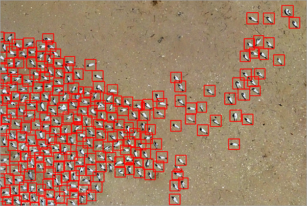
Seabirds are found near marine habitats, such as sea and wetlands, due to food availability. They mostly feed on fish and insects. The seabird population is declining at a much faster rate compared to other birds, as the coastal region is sensitive to pollution, commercial fisheries, habitat degradation, mineral extraction, human disturbance, and so on. Seabirds are also endangered by predatory species from both land and water. Apart from the geography of their habitat, they do not have much ability to defend their nest or protect their young ones. Breeding and laying of eggs happen in open habitats, such as bare ground and open sandy or rocky areas, on coasts and islands with little or no nest material.
The Royal tern and Caspian tern are two of the approximately 350 seabird species. These adult terns could be 45-60 centimeters in size and weigh 350-750 grams. Their size puts them in the category of small objects, so you need very high-resolution imagery to detect them. Recent innovations in drones and AI have enabled capturing high-resolution imagery over a large geographic area to detect objects of different shapes and sizes. Drones also decrease the disturbance to bird population. Drones are easier to deploy and can perform frequent surveys even after disasters such as hurricanes, oil spills, and so on. This deep learning model helps automate the task of detecting seabirds (Royal and Caspian terns) from high-resolution aerial imagery. This can help in mapping effective site protection areas for seabirds.
Model details
This model has the following characteristics:
- Input—This model uses high-resolution RGB imagery (1.0-centimeter resolution).
- Output—This model outputs a feature class containing detected seabirds.
- Compute—This workflow is compute intensive, and a GPU with minimum CUDA compute capability of 6.0 is recommended.
- Applicable geographies—The model is expected to work well in the West African coastal region.
- Architecture—This model uses the MaskRCNN model architecture implemented in ArcGIS API for Python.
- Accuracy metrics—This model has an average precision score of 0.75.
Access and download the model
Download the Seabird (Tern) Detection—Africa pretrained model from ArcGIS Living Atlas of the World. Alternatively, access the model directly from ArcGIS Pro, or consume it in ArcGIS Online using the Professional or Professional Plus user type.
- Browse to ArcGIS Living Atlas of the World.
- Sign in with your ArcGIS Online credentials.
- Search for Seabird (Tern) Detection—Africa and open the item page from the search results.
- Click the Download button to download the model.
You can use the downloaded .dlpk file directly in ArcGIS Pro or upload and use it in ArcGIS Enterprise. Additionally, you can fine-tune the pretrained model if necessary.
Release notes
The following are the release notes:
| Date | Description |
|---|---|
| September 2022 | First release of Seabird (Tern) Detection—Africa |