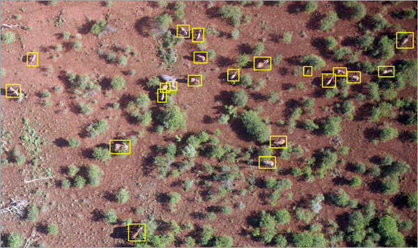
Elephants are the largest terrestrial living species. They are herbivorous animals and require 100 kilograms to 200 kilograms of food and about 230 liters of water each day. Their home range can expand up to 11,000 square kilometers. Their ability to find food and water sources is gained from traditional knowledge learned over generations. This knowledge, which is important for survival, is lost if elder elephants of the herd perish.
Elephants are endangered due to many reasons. They can be killed by poachers for their tusks, or captured and tamed for social status and for the circus. Changes in environment such as global warming, rain patterns, deforestation, and mining can lead to degradation of their habitat, forcing these animals to move to different areas in search of food and water. This can cause conflicts with humans as elephants move into human settlements and farmlands. They can also run into electrical fences and traps.
To avoid life-threatening incidents, and for their conservation, monitoring the elephants and their movements is of high importance. It is easier to monitor the elephants using aerial imagery, as it does not require human intervention or disturbance in elephants' natural habitat. Elephant Detection using aerial imagery is more efficient when performed over vast areas. This deep learning model helps automate the task of detecting elephants from high-resolution aerial imagery.
Model details
This model has the following characteristics:
- Input—High-resolution (3–13 centimeter) individual aerial images or an orthomosaic.
- Output—Feature class containing detected elephants.
- Compute—This workflow is compute intensive, and a GPU with minimum CUDA compute capability of 6.0 is recommended.
- Applicable geographies—The model is expected to work well with aerial imagery of southern African forests (South Africa, Botswana, and Namibia) or similar geographies.
- Architecture—This model uses the FasterRCNN model architecture implemented in ArcGIS API for Python.
- Accuracy metrics—This model has an average precision score of 0.857 for elephants.
Access and download the model
Download the Elephant Detection pretrained model from ArcGIS Living Atlas of the World. Alternatively, access the model directly from ArcGIS Pro using the Detect Objects Using Deep Learning tool, or consume it in ArcGIS Online using Professional or Professional Plus user type.
- Browse to ArcGIS Living Atlas of the World.
- Sign in with your ArcGIS Online credentials.
- Search for Elephant Detection and open the item page from the search results.
- Click the Download button to download the model.
You can use the downloaded .dlpk file directly in ArcGIS Pro, or upload and use it in ArcGIS Enterprise. Additionally, you can fine-tune the pretrained model if necessary.
Release notes
The following are the release notes:
| Date | Description |
|---|---|
| May 2022 |
|