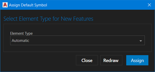
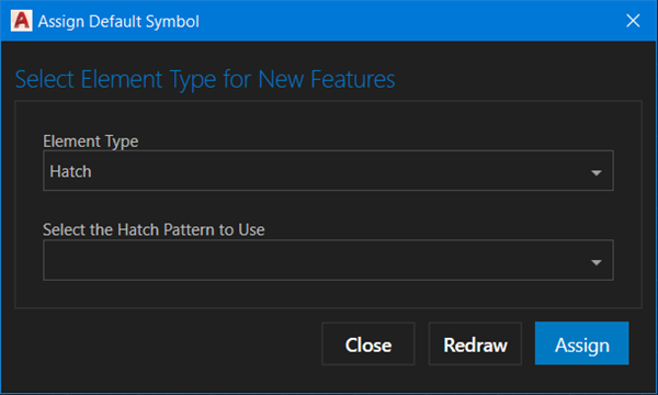
The Assign Default Symbol dialog box allows you to specify the default symbol used to apply and create point features in ArcGIS for AutoCAD and apply the chosen symbol options to the currently selected features of a point, multipoint, or polygon feature layer. When working with points or multipoint layers, you can choose between three entity types: point, block reference, and COGO point. You can set polygon symbols to Automatic (polyline outlines) or Hatch, where a hatch entity is used to draw the feature.
Note:
You can still create features with symbol variations that differ from the default symbol that is set. Those entities may will be recognized as features if they qualify according to the query filter of the specific feature layer.
Element type
Depending on the feature layer geometry and the element type you choose, you are presented with different context options to define the default symbol.
Point
When the Element Type drop-down menu is set to Point, the create feature tools and features drawn from a web feature layer use the default AutoCAD point symbol set in AutoCAD for a point entity. You can use the standard AutoCAD tools to control that point symbol, such as the layer color and entity color, and you can use the AutoCAD PDSIZE and PDMODE system variables to control the symbol and size of the symbol.

Block reference
This option is available for point and multipoint feature layers. When the Element Type drop-down menu is set to Block Reference, the create feature tools and features drawn from a web feature layer. You can use the standard AutoCAD tools to control the block reference symbol such as the layer color and entity color, and you can use other standard AutoCAD tools to control and manipulate the chosen block reference. If there is a ROTATION numeric field in the feature layer, the value of that field is used to automatically rotate the placement of the block symbol, and any modification to the block rotation is reflected in the field value as a property linked field.

Select the block to use
The Select the block to use option allows you to select any of the block references currently loaded in the drawing. To access blocks from block libraries or other sources, first load them into the drawing using one of the standard AutoCAD workflows. This includes the Esri block library that is provided with the ArcGIS for AutoCAD installation.
COGO point
If you are working in Civil 3D with point or multipoint feature layers, you can set the Element Type value to COGO Point. When this is selected, the create feature tools and features drawn from a web feature layer use COGO points to draw new features. You can use the standard AutoCAD tools to control COGO point symbols such as the layer color and entity color, and you can use other standard AutoCAD tools to control and manipulate the chosen COGO point. You can include the features in COGO point groups. To aid in the creation of COGO point groups, you can choose a default description that will be included on all new features placed with the ArcGIS for AutoCAD create tools or new features drawn from a web feature layer. If there is a ROTATION numeric field in the feature layer, the value of that field is used to automatically rotate the placement of the COGO point symbol. Any modification to the COGO point symbol rotation is reflected in the field value as a property linked field.

Enter a prefix for the point description
The Enter a prefix for the point description drop-down menu allows you to provide a description string that is used for the point's COGO point description. Use the COGO point description property to organize COGO points into point groups.
Automatic
This option is available for polygon feature layers. When a feature is created or redrawn by ArcGIS for AutoCAD, the Automatic option creates polyline entities. It will draw a closed polyline feature according to the current AutoCAD drawing settings and AutoCAD layer properties.

Hatch
This option is available for polygon feature layers. The Hatch option will draw hatch entities when a feature is created or redrawn by ArcGIS for AutoCAD.
The Select the Hatch Pattern to use drop-down menu allows you to provide a description string that is used for the point's COGO point description. Use the COGO point description property to organize COGO points into point groups.

Select the Hatch Pattern to use
The Select the Hatch Pattern to use drop-down menu allows you to select an existing AutoCAD hatch pattern name in the drawing to use as the default symbol.
Dialog box buttons
You can control how options are applied to the drawing using the dialog box buttons.
Assign button
The Assign button sets the default symbol to the chosen options for all future features of the selected feature layer placed with the create feature tools or when new features are added to the drawing from a web feature layer.
The default point feature symbol is used by ArcGIS for AutoCAD to create point features in the drawing in the following circumstances:
- On the Assign Default Symbol dialog box, you set the default symbol that will be applied to this point, multipoint, or polygon feature layer when using the Create Feature context menu option or createFeature option of the Esri_FeatureLayer command.
- A point feature drawn from a web point feature layer is added, redrawn, or synchronized from a feature service.
- The create new feature button is used to place a point feature on a point feature layer in the Esri Contents pane.
Redraw button
The Redraw button changes the entity type of the selected features of the specified feature layer to the chosen options.
Cancel button
The Cancel button closes the dialog box without making additional changes to the feature layer or the selected entities.