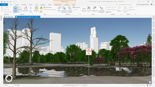
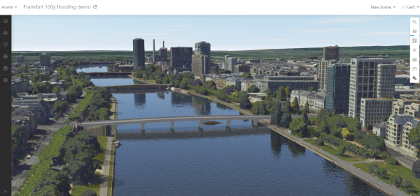
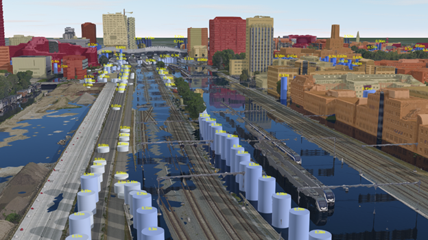
Including a layer that represents water bodies in your scene will enhance the overall visual experience for your audience. A realistic representation of water bodies such as oceans, rivers, lakes, or reservoirs adds aesthetic appeal and improves user engagement. By incorporating depth information, you can perceive the three-dimensional nature of water bodies. This depth perception helps users understand the terrain features beneath the water surface, which can highlight the impact of flooding and provides a more accurate representation of the environment.
Workflows
Water bodies can be visualized in several ways in ArcGIS. You can drape polygons representing water bodies directly on the ground surface. ArcGIS Pro, MapsSDK for JavaScript, and Scene Viewer support reflective water styling, which you can set in the properties of the layer. In ArcGIS Pro, you can set the symbology for the water bodies layer to an animated fill symbol. The appearance of the water surface can be modified in the properties of the symbol by changing the primary color, water body size, wave strength, and optionally, wave direction properties.

In Scene Viewer, use the Water style when you want to symbolize water polygon features. Set the scene performance to quality for water reflections and realistic atmosphere.
It is also possible to use a 3D polygon or 3D multipatch layer for the water surface of oceans, rivers, lakes, or reservoirs. In this case, the layer is not draped on the ground but is displayed at an absolute height, providing a more accurate water surface.

If you don't have 3D polygons for water bodies, you can use the 3D buildings solution to create them.
A 3D water layer not only enhances the overall visual experience, it can also be used to visualize and communicate the impact of flooding as a result of intense rainfall, storm surge, or sea level rise. The flood impact analysis solution provides tasks to analyze the impact of various flood scenarios on assets and visualize the results in 3D.

Considerations
Water animation and reflections are only supported for polygon feature layers through the animated fill symbol in ArcGIS Pro and the water style in Scene Viewer. Keep in mind that display performance can be affected if you have many 3D polygons in your water bodies layer. If this is the case, you need to convert the 3D polygons to 3D objects using the Layer 3D To Feature Class geoprocessing tool. This means the scene will no longer process the symbology as part of the drawing process but instead locks it into place as stored 3D objects. Water animation and reflections will be dropped from the symbology and only the color from the animated fill symbol will be used to draw the 3D object layer.
If you need to work with large volumes of 3D content on the web, it is recommended to share layers as scene layers to maximize performance.
Required software
You will need ArcGIS Pro or Scene Viewer to visualize water bodies realistically in ArcGIS. You will need an ArcGIS Online or ArcGIS Enterprise account to publish and share the layers across your organization.
Explore the following resources to learn more about visualizing utilities in ArcGIS.
ArcGIS help documentation
Reference material for ArcGIS products:
ArcGIS blogs, stories, and technical papers
Supplemental guidance about concepts, software functionality, and workflows:
Videos
Esri-produced videos that clarify and demonstrate concepts, software functionality, and workflows:
Tutorials
Guided, hands-on lessons based on real-world problems:
Solutions
Industry-specific configurations for ArcGIS:
- Use the 3D buildings solution to generate 3D water bodies.
- Use the Flood Impact Analysis solution to analyze the impact of various flooding scenarios on your assets.
Developer resources
Resources and support for automating and customizing workflows:
Esri community
Online 3D community to connect, collaborate, and share experiences:
- Ask the 3D community questions