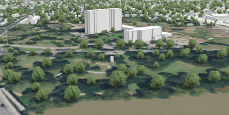
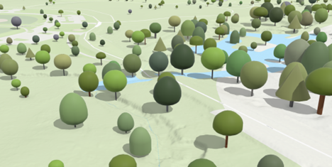
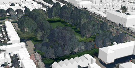
A layer representing trees is valuable when visualizing your city, community, or project areas. Trees are a significant part of the natural and urban environment, and including a tree layer in your scene helps users better understand the spatial relationships between various features and their surroundings, providing a more accurate representation of the environment. If you have detailed tree information such as exact location, size, and shape, the tree layer can be used in analytical workflows such as conducting a line of sight analysis or assessing shadow impact. There are several ways to create a layer that represents trees. Similar to buildings, you can model trees as individual objects or you can use a point cloud layer to represent the vegetation. Which one you choose will depend on the intended use and available input data.
Workflows
ArcGIS supports several workflows to create 3D trees as separate objects or features. As a starting point, you will need a point feature layer that represents the tree locations and has an attribute that describes the height of the trees. Having additional attributes such as tree width and species or genus is not required but will result in a more realistic tree layer. If you don't have a point feature class for trees, you can extract the tree locations from lidar using the Tree Management solution or leverage deep learning to detect trees in high-resolution imagery.
Tree symbols
Once you have a tree point feature layer, you can apply tree symbols to the points in ArcGIS Pro and Scene Viewer. Choose from a variety of 3D plants and trees to create thematic or realistic tree layers. You can set an attribute to provide real-world size of the objects.

Trees as objects
While symbols are a great way to visualize your trees in 3D, it is sometimes necessary to convert the tree layer into a multipatch or 3D object feature layer so it can be used in more advanced analysis in ArcGIS Pro with geoprocessing tools. Ensure your trees are symbolized with a tree symbol and use the Layer 3D to Feature Class tool to export the symbolized point features to generate volumetric trees. Alternatively, you can apply a procedural tree rule to your point features to generate volumetric trees. A procedural rule can leverage feature attribute information such as tree height, width, species, or genus to generate trees that can be used in analytical workflows.
The Tree Management solution provides workflows to extract tree locations and attributes from the input lidar and includes a rule to create analytical trees. CityEngine includes a vegetation library that contains rules and assets to generate analytical trees.

Point cloud data
When trees are not the focus of a scene and are needed for context, you can use a point cloud to visualize the built environment. The trees in the point cloud need to be classified to visualize them as a separate layer. The ArcGIS 3D Analyst extension in ArcGIS Pro can be used to classify trees manually or using a deep learning model. Once the trees are classified, filter the point cloud on the tree class code and share the layer as a scene layer to your organization.

Setting the layer properties
You can modify layer properties of the tree layer such as symbology, transparency, display filters, labels, and pop-ups to enhance the visualization. You can set the layer properties in ArcGIS Pro before you publish the layer or change them afterward in Scene Viewer or in another web app that supports modifying the properties of a layer. Display filters are useful for showing trees with a certain attribute or excluding a set of trees spatially from the layer. Labels and pop-ups provide information about the trees visually in the scene or when the user clicks the building.
Considerations
If you want to have your trees as individual features in a layer, and you need to make frequent changes, consider creating a scene layer with an associated feature layer. The scene layer provides fast display of large amounts of 3D trees and allows you to share the layer with stakeholders.
If your layer does not need to be updated often or you decide to visualize your trees with a point cloud, create the scene layer locally as a scene layer package and share this package as an item to your organization.
Use the thematic and realistic 3D tree layer hosted by Esri in ArcGIS Living Atlas if you don't have any tree data. This layer represents the OpenStreetMap (OSM) trees data and is updated every month with the latest OSM Daylight map distribution.
The tree management solution provides an end-to-end solution that can be used to inventory publicly owned trees, streamline inspection and maintenance activities, understand conditions, cultivate a volunteer workforce, and inform the public.
Required software
You can use ArcGIS Pro or CityEngine to create a layer with 3D trees as objects. To manage point clouds using LAS datasets, you can use ArcGIS Pro standard license with ArcGIS 3D Analyst extension. You can use ArcGIS Online or Enterprise user accounts to share the layer as a 3D scene service across your organization.
ArcGIS help documentation
Reference material for ArcGIS products:
ArcGIS blogs, stories, and technical papers
Supplemental guidance about concepts, software functionality, and workflows:
Tutorials
Guided, hands-on lessons based on real-world problems:
ArcGIS solutions
Industry-specific configurations for ArcGIS:
- Use the 3D buildings solution to generate buildings from lidar.
- Use the Tree Management solution to generate trees from lidar.
Esri Community
Online 3D community to connect, collaborate, and share experiences.
- Ask the 3D community questions