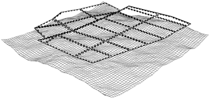
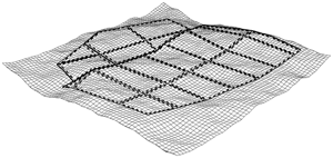
You can use the Align streets to terrain tool  to align graph networks to a terrain (map layers with attribute elevation defined) or to the y=0 level. You can access the tool in the following ways:
- Click the Align streets to terrain tool in the main toolbar.
- Click Graph > Align streets to terrain in the main menu.
Settings
The following parameters control the alignment:
Align function | The alignment function to apply to the nodes of the graph.
|
Terrain | The terrain to align the graph. All map layers with an "elevation" attribute plus the y=0 level are listed here. |
Offset | The offset to add after alignment to the y-coordinate of the nodes. |