Elevation analysis geoprocessing services allow you to perform raster analysis on world elevation data. Use the Profile geoprocessing service tool to create elevation profiles along any given polyline features. Use the Viewshed geoprocessing service tool to create viewsheds for any given observation point features anywhere on the surface of the earth. Use the Summarize Elevation tool to calculate summary statistics of elevation, slope, and aspect for any given point, polyline, or polygon features. To publish the Elevation geoprocessing services, ArcGIS Server 10.9.1 or later with an Advanced license is required. The data preparation steps below require ArcGIS Pro 3.1 or later with a Standard or Advanced license.
Tools and data location
The geoprocessing tools and data for setting up the elevation geoprocessing services are organized under the ElevationGP folder at \\<server-ip>\CollectionX_source_documents\data\WorldElevation, where <server-ip> is the network IP or server name of the data appliance, and CollectionX is the collection where the World Elevation content is located: Collection2 (World Standard), Collection3 (World Advanced), Collection4 (North America Standard), or Collection5 (North America Advanced). The elevation analysis geoprocessing services are not included with Collection 1.
Note:
In the following steps, when the UNC path \\<server-ip>\CollectionX_source_documents\data is mentioned, <server-ip> denotes the network IP or server name of the data appliance, and CollectionX denotes the collection where the World Elevation content is located.
Use the following workflows to publish the Elevation and ElevationSync .json files.
Repair the mosaic dataset paths
The elevation geoprocessing services use a set of derived and referenced mosaic datasets as the elevation data source. These mosaic datasets were updated for your environment when you previously ran the Prepare Elevation tool while publishing the Terrain service. In addition, path information has been filled in for configuration and .json files required for publishing.
Publish the Elevation and ElevationSync .json files
Follow the steps below to publish the Elevation.json and ElevationSync.json files using ArcGIS REST administrator.
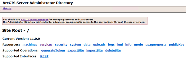
- Sign in to the ArcGIS Server Administrator Directory using the URL https://<server name>:6443/arcgis/admin.

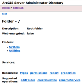
- Click services to view the available services under the root folder.
- Click CreateService.

The Create Service page appears.
- Copy and paste the contents of .\WorldElevation\ElevationGP\json\Elevation.json into the Service (in JSON format) field.

- Click Create to complete the publishing of the Elevation geoprocessing service.
The Elevation service is ready to use.
- Repeat steps 1 through 5 using ElevationSync.json instead of Elevation.json to complete the publishing of the ElevationSync geoprocessing service.
For information about how to use the elevation analysis services, see Use the elevation analysis geoprocessing services.