Organizations can make lidar point clouds accessible via the web by hosting the data on ArcGIS Online or your ArcGIS Enterprise portal. Users can then visualize the data using either the ArcGIS Online scene viewer in a web browser or using a custom web application.
Scene viewer includes measurement tools that enable users to determine 3D distances (point-to-point, height, and distance on the ground), and rendering options that can be changed by the user based on elevation, classification code, and return value. Esri’s Indexed 3D Scene Layer (I3S) format provides support for hosting arbitrarily large point clouds.
To visualize lidar point clouds online:
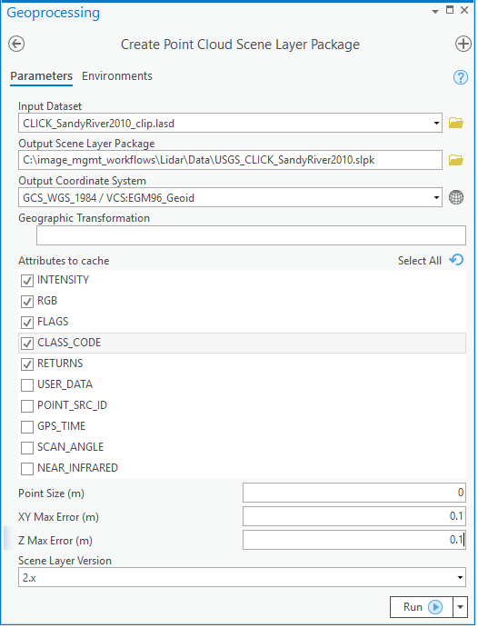
- Use the Create Point Cloud Scene Layer Package geoprocessing tool to convert the LAS points (referenced by a LAS dataset, or directly from a single LAS file) into the optimized I3S format, which is then prepared for upload as a scene layer package (.slpk).
- Upload and publish the SLPK using either the Share Package geoprocessing tool or using the web interface from ArcGIS Online.
Creating the SLPK
In ArcGIS Pro, run the Create Point Cloud Scene Layer Package tool, selecting attributes to cache that are appropriate for your dataset. Learn more about point cloud scene layers.
Note:
Be sure to select Scene Layer Version 2.x.

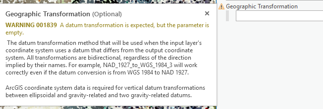
If you are changing the coordinate system of the output, pay close attention to any warnings about the geographic transformation from input to output coordinate system.

Note:
The user interface does not provide the ability to a browse to locate and select geographic transformations, so you may have to find the proper transformation and enter the string that identifies it. Learn more about geographic coordinate system transformations and coordinate systems and projections.
You can also download the list of supported geographic and vertical transformations.
Publishing the SLPK
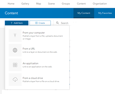
When ready to share the SLPK, you will log in to ArcGIS Online or your ArcGIS Enterprise portal, navigate to Content, then select Add Item > From your computer to upload and publish the SLPK.

Alternatively, you can also run the Share Package tool in ArcGIS Pro.
Note:
You must be logged in to ArcGIS Online or your ArcGIS Enterprise portal before running this tool.

Visualizing point cloud layers using scene viewer
Once your SLPK is published to ArcGIS Online or your ArcGIS Enterprise portal, it's easy to visualize from any web browser. Check out this tutorial creating a 3D web scene of the city of Schiedam to try it out for yourself.