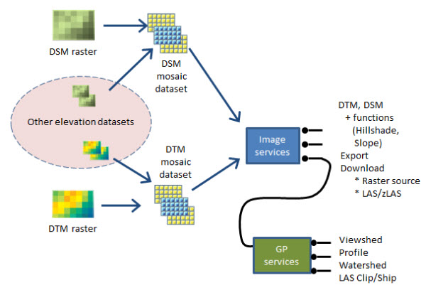
Multiple lidar projects can be managed by incorporating the DTM and DSM surfaces into larger managed collections. Refer to Elevation best practices for the details on this process.
When this stage is complete, if end users will need to access the point cloud files, you can also configure the mosaic dataset to share 3D point files for user download.
A simple diagram is provided below, but note that this stage does not limit you to processing one data collection (one lidar project) at a time. In the case of multiple lidar projects, the first three stages (Manage lidar collections with LAS datasets, Determine parameters to generate DTM and DSM, and Create derived rasters) would be repeated for each project, and then all datasets can be integrated into the managed elevation collection in this stage.

Simplified configuration for organizations that do not have ArcGIS Image Server
The section above presumes that your organization has a need to share elevation data as dynamic image services, and has access to ArcGIS Image Server.
However, if you do not have ArcGIS Image Server, there are two alternatives:
- You can create a tile cache and host it on ArcGIS Online as an elevation service (suitable as an elevation surface for visualization, but not for accessing pixel values).
- You can publish a cached visualization of your elevation data to ArcGIS Online that users can use to find and download the elevation data:
- The elevation files may be processed to create a hillshade visualization of your terrain, stored and shared on ArcGIS Online as raster tile cache (Esri basemap format).
- The source elevation files (32-bit floating point data, tiff format) may then be copied to a convenient location (e.g. cloud storage or an FTP site available to your organization) to enable download of the data when required by your colleagues.
- A feature class representing the elevation tile boundaries and tile names may be published on ArcGIS Online, with a field containing the URL for download of each tile.
- The raster tile cache to be visualized on ArcGIS Online may be created as follows:
- Create a mosaic dataset containing all of the bare earth DTM elevation tiles.
- Add a raster function to the mosaic dataset to render a grayscale hillshade. Load the mosaic dataset into the map to ensure the rendering is correct.
- Add a custom field to the mosaic dataset attribute table named "URL_to_Download", then populate this field with the unique URL for each tile in your online storage (e.g. cloud storage or FTP site).
- Download Raster Tile Cache Tools to:
- Generate the raster tile cache
- Publish the raster tile cache on ArcGIS Online
- Generate the feature class with tile boundaries and download URLs
- Publish the feature class as a feature service on ArcGIS Online
- Repeat the above steps for the first return DSM elevation tiles.