ArcGIS Flight is a mobile app that enhances the way drone flights are planned and conducted. Drone pilots can access their geospatial content during flight planning, providing context and situational awareness.
The app offers different flight modes for specific use cases, while ensuring compliance with federal regulations. Flights are fully automated and repeatable for consistent high-quality imagery. Postflight, the app enables in-field quality control and integration of captured imagery for further processing, analysis, sharing, and visualization using ArcGIS Online and ArcGIS Reality Suite, or Site Scan for ArcGIS.
ArcGIS Flight interface
ArcGIS Flight has interfaces for preflight, during flight, and postflight.
Preflight, the ArcGIS Flight interface includes the following main components (the numbers in the image correspond to the numbers in the table):

| Label | Component | Description |
|---|---|---|
1 | Missions menu | Find all missions in the project and perform postflight image capture. |
2 | Drone status | View the status of the drone, such as distance from home location, altitude, battery percentage, and drone model. |
3 | Cloud sync button | This button appears for Site Scan users. You can sync flights, missions, and data (such as flight plans, Site Scan layers, and fleet management) between ArcGIS Flight and Site Scan cloud. |
4 | Project lists | View a list of all your projects. You can sort projects alphabetically, by distance from the tablet's current location, or by creation date. |
5 | RTK (Real-Time Kinematic) | View the connection status and settings. This option is only available for RTK-supported drones. See RTK Settings for more information. |
6 | GPS | View the total number of satellites connected to the drone. |
7 | Drone list | View a list of supported drones to choose from. See Hardware and compatibility for the current list of supported drones. |
8 | Settings | A Site Scan icon appears for Site Scan users. To learn how to customize your preferences, see Settings. |
9 | Signal strength | View the remote controller signal strength. |
10 | Flight modes | To learn about flight modes, see Choose a flight mode. |
11 | Flight plans | View and manage your saved flight plans and refly previously flown missions. |
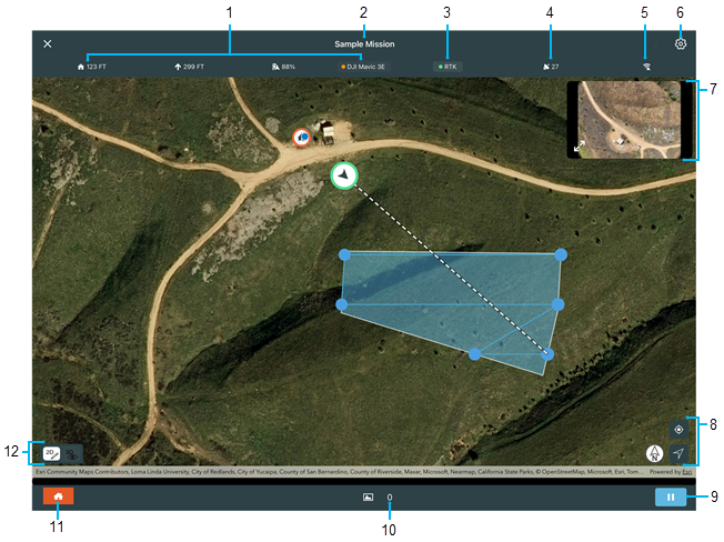
During flight, the ArcGIS Flight interface includes the following main components (the numbers in the image correspond to the numbers in the table):

| Label | Component | Description |
|---|---|---|
1 | Drone status | View the status of the drone, such as distance from home location, altitude, battery percentage, and drone model. |
2 | Mission name | The name of the mission. |
3 | RTK (Real-Time Kinematic) | View the connection status and settings. This option is only available for RTK-supported drones. See RTK Settings for more information. |
4 | GPS | View the total number of satellites connected to the drone. |
5 | Signal strength | View the remote controller signal strength. |
6 | Settings | View mid-flight app notifications. |
7 | Video feed | View video feedback from the drone. |
8 | Center to map | Center the map to the mission location or to the drone location. |
9 | Pause/resume mission | Tap to pause or resume the mission. |
10 | Number of images | View the total number images that are being collected during the mission. |
11 | Home button | Return the drone to its home position. The home button appears when you pause a mission. |
12 | 2D/3D view | View the mission in 2D or 3D. |
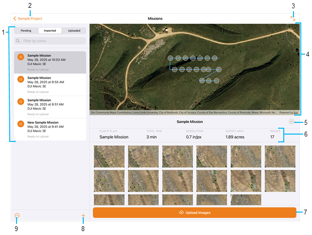
Postflight, the ArcGIS Flight interface includes the following main components (the numbers in the image correspond to the numbers in the table):

| Label | Component | Description |
|---|---|---|
1 | Missions | Find missions that are pending or imported, filter by name, or view the list. Site Scan users also have an Uploaded button. |
2 | Project name | The name of the project. Tap it to return to the project home screen. |
3 | Expand mission | Hide the side panel. |
4 | Map | Display the mission flight path and the locations of the images on the map. |
5 | Mission actions | Rename or refly the mission, view geospatial video logs, checklists, and advanced information, or delete the mission. |
6 | Mission info | View the mission name, total time, resolution, survey area, and images. |
7 | Import images | Open the image import selection panel. See Prepare imagery for more information. |
8 | Create mission | Create a new mission in the project. |
9 | Mission list actions | Select and delete multiple missions, or import images. |
ArcGIS Flight Connection interface
ArcGIS Flight Connection has interfaces for preflight and during flight.
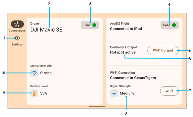
Preflight, the ArcGIS Flight Connection interface includes the following main components (the numbers in the image correspond to the numbers in the table):

| Label | Component | Description |
|---|---|---|
1 | Video feed | View the video feed before flight. |
2 | Settings | View the version number, terms of service, and check for updates. |
3 | Drone name | View the drone name if the drone is connected or appears disconnected. |
4 | Drone status | View the status of the drone. Green indicates connection from the drone to the ArcGIS Flight Connection app. Red indicates that ArcGIS Flight Connection and the drone are not connected. |
5 | App connection status | View the connection status. Green indicates a connection with ArcGIS Flight, orange indicates whether the controller Wi-Fi is on a network or if the controller hotspot is enabled, and red indicates that the controller is not hosting a hotspot and has no Wi-Fi connection. |
6 | Wi-Fi hotspot | View the controller hotspot status. |
7 | Controller hotspot status | View the Wi-Fi hotspot settings. |
8 | Wi-Fi settings | View the Wi-Fi settings. |
9 | Wi-Fi connection | View the Wi-Fi signal strength and the name of the Wi-Fi hotspot. |
10 | Battery status | View the drone's battery percentage. |
11 | Drone signal status | View the signal strength of the drone. |
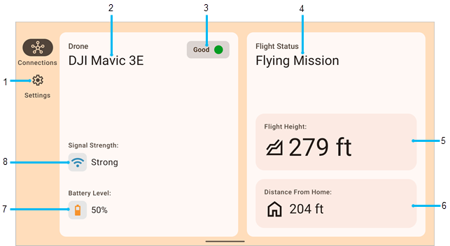
During flight, the ArcGIS Flight Connection interface includes the following main components (the numbers in the image correspond to the numbers in the table):

| Label | Component | Description |
|---|---|---|
1 | Video feed | View the video feed during flight. |
2 | Settings | View the version number, terms of service, and check for updates. |
3 | Drone name | View the drone name if the drone is connected or appears disconnected. |
4 | Drone status | View the status of the drone. Green indicates connection from the drone to the ArcGIS Flight Connection app. Red indicates that ArcGIS Flight Connection and the drone are not connected. |
5 | Flight status | View the flight status, such as taking off, flying mission, and returning. |
6 | Flight height | View the flight height from the takeoff location. |
7 | Distance from home | View the horizontal distance from the drone takeoff location. |
8 | Battery status | View the drone's battery percentage. |
9 | Drone signal status | View the signal strength of the drone. |