These instructions are for deploying Esri Vector Basemaps U.S. Edition with vector contours and hillshade WMA (new user).
For information about what's included with Esri Vector Basemaps, see Esri Vector Basemaps content.
Note:
Before you proceed, review the system requirements to confirm that you can deploy Esri Vector Basemaps U.S. Edition with vector contours and hillshade on your system.
Once you confirm that the system requirements are met, the workflow to set up Esri Vector Basemaps U.S. Edition with vector contours and hillshade WMA styles for a new user is as follows:
- Upload the three packages to your ArcGIS Enterprise portal.
- Publish the three hosted tile layers (services).
- Publish U.S. Edition WMA with multisource tile layers (map styles).
- Share tile layers (map styles).
Upload the three packages to your ArcGIS Enterprise portal
Esri Vector Basemaps with vector contours and hillshade includes three vector tile packages (.vtpk) in the Web Mercator Auxiliary Sphere (WMA) projection: Esri_Vector_Basemap_DA2026_Install.vtpk, Esri_Vector_Contours_DA2026_Install.vtpk, and Esri_Vector_Hillshade_DA2026_Install.vtpk.
Complete the following steps for the three packages:
- First, download all the Esri Vector Basemaps and Esri Vector Basemaps 2026 Contours and Hillshade files from My Esri or copy the entire USB flash drive contents to your local computer if you have not already done so. Note that all files must be downloaded from My Esri to the same location before unzipping.
- Unzip the first Esri Vector Basemaps 2026 file with 7-Zip software (free from www.7-Zip.org), and the rest will automatically unzip with it. Unzip the first Esri Vector Basemaps 2026 Contours and Hillshade file to the same location as Esri Vector Basemaps, and the rest will automatically unzip with it.
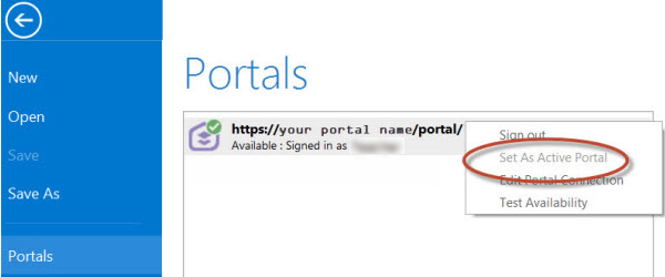
- Start ArcGIS Pro, sign in to your
ArcGIS Enterprise portal, click the Options button
 , and click Set As Active Portal.
Note:
You must sign in and connect to your portal before you proceed. You cannot provide your portal username and password when using the Share Package tool later in these instructions. The tool obtains your credentials from ArcGIS Pro.
- Create a project.
- Click the Analysis tab, and click Tools in the Geoprocessing group.

The Geoprocessing pane appears.
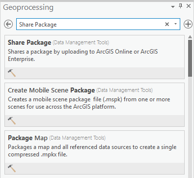
- In the Geoprocessing pane, search for Share Package, and select the Share Package (Data Management Tools) tool from the search results.
- On the Share Package dialog box,
do the following:
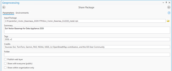
- For Input Package, provide the path to the vector tile package, for example, C:\Projects\Esri_Vector_Basemaps_2026\VTPK\Esri_Vector_Basemap_DA2026_Install.vtpk.
- For Summary, type Esri Vector Basemap for Data Appliance 2026.
- For Tags, type 2026, v2.
Caution:
Do not change the Credits parameter value and do not check the Publish web layer, Share with everyone, or Share within organization only check boxes.
- Click Run.
It will take approximately 30 to 120 minutes to upload the Esri_Vector_Basemap_DA2026_Install.vtpk package to your portal. A Share Package Uploaded Successfully message appears in the Share Package window once the upload is complete.
Note:
You can upload all three packages concurrently. You do not need to wait until each package is uploaded successfully before uploading additional packages.
- Repeat steps 4-8 for Esri_Vector_Contours_DA2026_Install.vtpk. On the Share Package dialog box,
do the following:
- For Input Package, provide the path to the vector tile package, for example, C:\Projects\Esri_Vector_Basemaps_2026\VTPK\Esri_Vector_Contours_DA2026_Install.vtpk.
- For Summary, type Esri Contours Basemap for Data Appliance 2026.
- For Tags, type 2026, v2.
It will take more than 120 minutes to upload Esri_Vector_Contours_DA2026_Install.vtpk. A Share Package Uploaded Successfully message appears in the Share Package window once the upload is complete.
- Repeat steps 4-8 for Esri_Vector_Hillshade_DA2026_Install.vtpk. On the Share Package dialog box,
do the following:
- For Input Package, provide the path to the vector tile package, for example, C:\Projects\Esri_Vector_Basemaps_2026\VTPK\Esri_Vector_Hillshade_DA2026_Install.vtpk.
- For Summary, type Esri Hillshade Basemap for Data Appliance 2026.
- For Tags, type 2026, v2.
It will take more than 120 minutes to upload Esri_Vector_Hillshade_DA2026_Install.vtpk. A Share Package Uploaded Successfully message appears in the Share Package window once the upload is complete.
- Through your portal, confirm that the three .vtpk files uploaded successfully.
- Open a web browser and sign in to your portal.
All three packages are located in the root folder.
- Under Details, confirm that the Size value of each tile package matches the size for your vector tile package and Enterprise version in the following table and Shared with indicates that each item is not shared.
Vector tile package .vtpk file Enterprise version Size Esri_Vector_Basemap_DA2026_Install.vtpk (WMA)
11.1, 11.3, and 11.5
50,503.922 MB
Esri_Vector_Contours_DA2026_Install.vtpk
11.1, 11.3, and 11.5
162,738.703 MB
Esri_Vector_Hillshade_DA2026_Install.vtpk
11.1, 11.3, and 11.5
102,393.125 MB
Your item should look similar to the following when uploading Esri_Vector_Basemap_DA2026_Install.vtpk (WMA) in Enterprise. The size in the item Details section should match the size in the chart above:

- Open a web browser and sign in to your portal.
Note:
If the size is not correct for a package, delete the item and upload the tile package again. You may want to discuss the problem with your portal administrator.
See the Troubleshoot Esri Vector Basemaps topic for more information.
Publish the three hosted tile layers (services)
Now you'll publish the three hosted tile layer services from your portal: Esri Vector Basemap, Esri Vector Contours, and Esri Vector Hillshade.
- Sign in to your
ArcGIS Enterprise portal.
Note:
Your account must have publishing credentials. - In My Content, go to the item page for the vector tile package (Esri_Vector_Basemap_DA2026_Install.vtpk) you uploaded to your portal.
- Click Publish, change the title to Esri_Vector_Basemap_v2, and click Save (if you are using 11.1, click Next) to publish the service.
Note:
Changing the name to Esri_Vector_Basemap_v2 enables the hosted tile layer and URL path to remain stable when the underlying tile set is updated in future releases.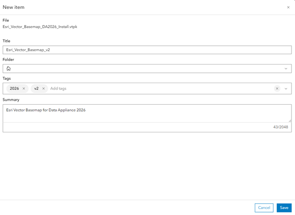
Note:
It will take 30 to 120 minutes to create the hosted layer, depending on your system configuration.
The Esri_Vector_Basemap_v2 hosted tile layer is created. After publishing in 11.1, 11.3, or 11.5, the Vector Tile Service URL includes Esri_Vector_Basemap_v2, but the item is named Esri_Vector_Basemap_DA2026_Install. You must change the hosted tile layer's title.

- In 11.1, 11.3, or 11.5, go to the item page for the hosted tile layer (Esri_Vector_Basemap_DA2026_Install), click the Edit button
 next to the current item title on
the Overview tab of the item page, change the title to Esri_Vector_Basemap_v2, and click Save.

- Repeat steps 2-4 for Esri_Vector_Contours_DA2026_Install.vtpk. Change the title to Esri_Vector_Contours_v2.
- Repeat steps 2-4 for Esri_Vector_Hillshade_DA2026_Install.vtpk. Change the title to Esri_Vector_Hillshade_v2.
Publish U.S. Edition WMA with multisource tile layers (map styles)
You'll publish the U.S. Edition WMA with multisource map styles next.
The VectorStylePublisher geoprocessing toolbox can be run in ArcGIS Pro. This toolbox publishes 40 U.S. Edition WMA with multisource tile layers to your portal.
Note:
Esri Vector Basemaps includes many style varieties that provide cartographic options for basemap use. You can choose a default style installation or a custom style installation. The default installation deploys all the styles. The custom installation allows you to select a smaller set of styles for your organization to actively use on your portal. See the Directory of Esri Vector Basemaps map styles for details on available styles. Create a VectorBasemapStyles directory on your local machine and copy either all the style folders or your custom subset of styles to this new local directory before deploying your styles.
These instructions assume that the toolbox and VectorBasemapStyles folder are on your local computer.

Note:
You must have a portal account assigned to the default Publisher or Administrator role, or your account must be assigned to a custom role that has privileges to create content and publish hosted tile layers.
- Start ArcGIS Pro, sign in to your
ArcGIS Enterprise portal, click the Options button
 , and click Set As Active Portal.
 - Create a project.
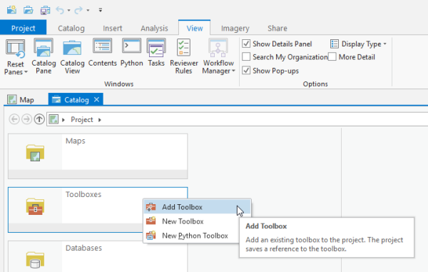
- Click the View tab, click Catalog View in the Windows group, right-click Toolboxes, and click Add Toolbox.
- Browse to the location on your local computer where you unzipped the files you downloaded or copied the contents of the USB flash drive, click VectorStylePublisher.tbx, and click OK.
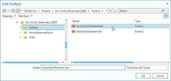
The VectorStylePublisher toolbox is added to the project.
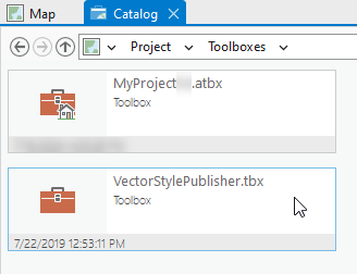
- Double-click Toolboxes and double-click VectorStylePublisher.tbx.
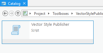
- Double-click the Vector Style Publisher script.
- On the Vector Style Publisher dialog box,
click the Parameters tab and do the following:
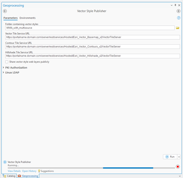
- For Folder containing vector styles, browse to the location of the multisource VectorBasemapStyles folder on your local computer, for example, C:\Projects\Esri_Vector_Basemaps_2026\VectorBasemapStyles\US_Edition\new_user\WMA_with_multisource. If you created a custom VectorBasemapStyles folder, browse to that location.
- For Vector Tile Service URL, provide the URL of the Esri Vector Basemap hosted
tile layer, for example, https://portalname.domain.com/server/rest/services/Hosted/Esri_Vector_Basemap_v2/VectorTileServer.
Note:
The vector tile service URL is in the URL section of the Esri_Vector_Basemap_v2 hosted tile layer item page. Click the Copy button and paste the URL in the Vector Tile Service URL parameter text box.

- For Contour Tile Service URL, provide the URL of the Esri Vector Contours hosted tile layer, for example, https://portalname.domain.com/server/rest/services/Hosted/Esri_Vector_Contours_v2/VectorTileServer.
- For Hillshade Tile Service URL, provide the URL of the Esri Vector Hillshade hosted tile layer, for example, https://portalname.domain.com/server/rest/services/Hosted/Esri_Vector_Hillshade_v2/VectorTileServer.
- To share the layers publicly, check the Share vector style web layers publicly check box.
Note:
If you are using a portal with PKI authentication, expand PKI Authorization and provide values for the PKI_Certificated_file_(.pfx) and PKI Private Password parameters.

If you are using a portal with Linux LDAP authentication, expand Linux LDAP and provide information for the Sign In Username and Sign In Password parameters.

- Click Run.
The 40 U.S. Edition WMA with multisource vector tile layers (map styles) are created in your assigned ArcGIS Enterprise account. You can view the items in My Content. A total of 46 items are listed: 40 U.S. Edition WMA with multisource vector tile layers, three .vtpk files, and three hosted tile layers.
Share tile layers (map styles)
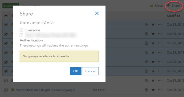
The items created are private unless you check the Share vector style web layers publicly check box in step 7 above to make them public.
Alternatively, you can select the map items in your portal and change the sharing settings.
Note:
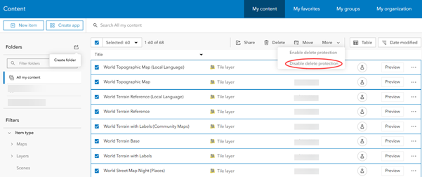
Delete protection for all items is applied on publishing the tile layers. To change the protection setting, open the item and click the Settings tab. Under Delete Protection, uncheck Prevent this item from being accidentally deleted and click Save.
To change the protection setting in 11.5, you can select the map items in your portal, select the More drop-down menu, and select Disable Delete Protection.
Once you set up Esri Vector Basemaps, you can do the following: