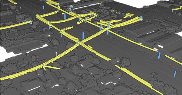
The classification of point cloud datasets to identify distribution wires is useful for identifying vegetation encroachment around power lines. Such workflows are important for preventing fires and power outages and are typically manual, recurring, and labor-intensive.
This model is designed to extract distribution wires at the street level. Its predictions for high-tension transmission wires are less consistent with changes in geography as compared to street-level distribution wires. In the case of high-tension transmission wires, a lower recall value is observed as compared to the value observed for low-lying street wires and poles.
License requirements
To complete this workflow, the following are the license requirements:
- ArcGIS Desktop—ArcGIS 3D Analyst extension for ArcGIS Pro
Model details
This model has the following characteristics:
- Input—Point cloud in LAS dataset file format (.lasd) or as per Classify Point Cloud Using Trained Model tool.
- Output—Classified point cloud with three classes: distribution wires, poles, and background.
- Compute—This workflow is compute intensive and a GPU with compute capability of 6.0 and 8 GB dedicated VRAM is recommended.
- Applicable geographies— The model is expected to work within any geography. However, results can vary for datasets that are statistically dissimilar to training data.
- Architecture—This model uses the RandLANet architecture as implemented in ArcGIS API for Python.
- Extra attributes—Input point clouds should have at least x, y, and z.
- Accuracy metrics—For the validation dataset, the F1 score is 0.945867 for distribution wires and 0.621527 for poles.
- Class mapping—Points predicted as distribution wires are mapped to class code 14, poles are mapped to class code 15, and background is mapped to class code 0.
Access and download the model
Download the Power Line Classification pretrained model from ArcGIS Living Atlas of the World. Alternatively, access the model directly from ArcGIS Pro, or consume it in ArcGIS Image for ArcGIS Online.
- Browse to ArcGIS Living Atlas of the World.
- Sign in with your ArcGIS Online credentials.
- Search for Power Line Classification and open the item page from the search results.
- Click the Download button to download the model.
You can use the downloaded .dlpk file directly in ArcGIS Pro.
Release notes
The following are the release notes:
| Date | Description |
|---|---|
|
|