What is Location Architect?
In this topic
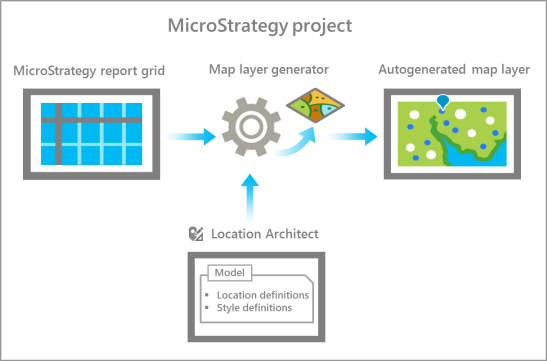
With Location Architect, you can build a model that defines geographic relationships in your MicroStrategy data and a corporate style for maps in your organization. When a model is created and applied to a project in your organization's MicroStrategy system, map generation becomes an automated process. This allows you to more quickly and easily create map-enabled reports that comply with corporate style standards.

Creating a model in Location Architect involves two main tasks: creating location definitions and creating style definitions. Location definitions determine what features will be drawn on a map based on the data in a report. Style definitions determine how features will be drawn on a map based on report data.
Location definitions
To build a model in Location Architect, you define relationships between attribute forms in your MicroStrategy project and ArcGIS location types such as Address, US State, or Country. These relationships, called location definitions, are stored in your model. Location definitions are used by Esri Maps for MicroStrategy at run time to automatically generate a map layer from the data in a report.
For example, suppose a report has the following grid:
| Zip Code | Profit |
|---|---|
90250 | 12,326.65 |
90266 | 9,105.35 |
In your model, you create the following location definition named Customer Zip Codes, which specifies a relationship between the Zip Code[ID] attribute form in the grid and the US ZIP Code location type:
| Name | Location type | Fields |
|---|---|---|
Customer Zip Codes | US ZIP Code | Zip Code[ID] |
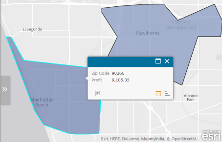
When a map is generated from this report using the above location definition, a layer showing the 90250 and 90266 ZIP Code areas is drawn.

To learn more, see Create location definitions.
Location definition identifiers
Your MicroStrategy project may have attributes—for example, customer name or store name—that are not associated with location data such as addresses or longitude and latitude values. If these attributes are used in a report grid without associated location data, they cannot be displayed on a map.
For example, a report may have a grid with the following columns: Customer name and Revenue. Without location values, such as addresses, to define where the customers are located, Esri Maps for MicroStrategy will not have the necessary information to plot the customer locations on a map.
With Location Architect, you can create a relationship between an attribute in your project and the necessary location data by mapping the attribute to an existing location definition in the model. When the attribute is mapped to a location definition, a location definition identifier (LDI) is created. An LDI defines a relationship between the attribute and the location fields specified in the location definition. A location definition can have more than one LDI, but each LDI should only be associated with one location definition.
To learn more, see Create location definition identifiers.
Style definitions
With Location Architect, you can create style definitions for any stylable element in your MicroStrategy project. A stylable element is any column in a BI dataset that contains attribute forms or metrics (for example, revenue, unit cost, or retailer type) for which style properties (for example, color, size, and grouping method) can be defined. When style properties are defined for a stylable element in your data, a style definition is created in the model.
Style definitions are used by Esri Maps for MicroStrategy when drawing features in the map layer. For example, if you have a revenue column in your report grid, the style properties defined for revenue in the model are applied at run time to the generated layer. If the report grid contains more than one stylable element, Esri Maps for MicroStrategy uses the style definition corresponding to the rightmost stylable element in the grid when drawing the layer. If a report has columns associated with multiple style definitions in the model, all of these will be included in the list of styles available to apply to the autogenerated layer in Esri Maps for MicroStrategy.
When you create a style definition, you have the option of defining style properties for any of the three geography types—points, lines, or areas. If you choose not to explicitly define style properties for a geography type, default style properties will be applied for that type as needed when the layer is drawn on the map.
To learn more, see Create style definitions.
Create a model
To learn how to create a simple model in Location Architect, see Create a simple model.