Note:
You need the following account and license types for this workflow:
- Microsoft license—You need a Microsoft 365 license to use this workflow.
- ArcGIS account type—Standard users can perform some of the functions of this workflow. You must sign in to view settings that require an account.
You can view your profile and account settings in ArcGIS for Microsoft 365.
See Get started with ArcGIS for Microsoft 365 to learn more about ArcGIS for Microsoft 365 components.
To view your user profile and account settings, complete the following steps:
- To view details about the account you used to access ArcGIS for Microsoft 365, click the Settings button
 in the map tools.
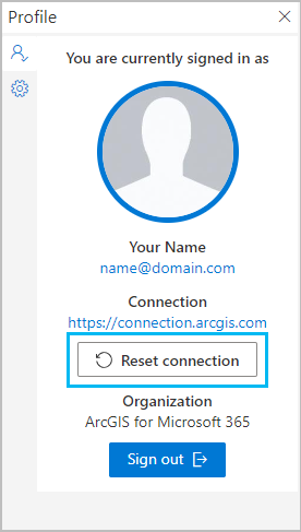
The Profile pane appears.
- To view your user settings, click the Settings tab in the Profile pane.
The Settings pane appears.
Options
The options described below are available in the Settings and Profile panes.
Sign in
You can sign in to and out of your ArcGIS account from the Profile pane.
Reset connection
You may need to reset a connection to remove a map's content or switch your ArcGIS organization connections. When you click the Reset connection button, the web part clears all layers on the map, returns the basemap to the default map, clears all selections and analysis layers, restores all settings in the Share pane to the default setting, and returns you to the sign-in page where you can sign with a different connection.
To reset the map and connection, do the following:
- In the Profile pane below the active connection, click Reset connection.

A confirmation message appears.
- Click Reset.
The Choose ArcGIS connection drop-down menu appears, prompting you to choose a connection and sign in again.
Help
A link to the ArcGIS for Microsoft 365 help is available in the Settings pane.
Feedback
A link to the ArcGIS for Microsoft 365 Esri Community page is available in the Settings pane. Use Esri Community to search for answers to common ArcGIS for Microsoft 365 questions, get help from users and developers, and submit feedback to improve the product.
Attribution
Each map contains a basemap and may contain a variety of data layers and reference layers added from your organization, geographic policy, the community, and public content published by the GIS community, including Esri, local governments, and agencies around the world. The Attribution section in the Settings pane identifies the source or authors of content currently included in the active map.
Esri User Experience Improvement program
The Esri User Experience Improvement (EUEI) program is a voluntary agreement between you and Esri that allows Esri to collect anonymous data about ArcGIS for Microsoft 365. You can manage your EUEI permissions from the Settings pane. Turn on the Send usage data to Esri toggle button to allow anonymous usage data to be collected occasionally. This setting is off by default.