Submodels allow you to create more complex, realistic models. A Suitability Modeler model composed of submodels can be considered a model of models.
Use of submodels
When identifying the best locations to site or conserve, often, the subject of the suitability model not only makes trade-offs between the individual criterion, but also makes trade-offs between competing objectives. Each objective can be captured in different submodels.
For example, consider a suitability model identifying locations to conserve for black bears. From the perspective of a bear, the best sites will be selected by making trade-offs between three primary objectives: habitat, food supply, and security. In each of these objectives, bears will make trade-offs between the criteria influencing that objective. For instance, the criteria for the security objective may include a preference for being farther away from roads and buildings, but a preference for being closer to forested and preserved land.
When creating a submodel, the focus is on the objective of that submodel. When determining, transforming, and weighting criteria, you need to identifying the most suitable areas relative to that objective. When you combine the submodels, the trade-offs between the objectives are made.
Certain criteria may be used in different submodels and have different meaning. For example, a suitability model to locate a new ski resort may be composed of submodels for identifying the areas that have the most ideal snow conditions, finding the best possible terrain, and determining the locations with the lowest construction costs. Flatter slopes may be more preferred in the construction cost submodel. In contrast, providing a variety of ski slopes, including steep slopes, may be more preferred in the terrain submodel. Slope would be added to each submodel and transformed appropriately to capture the specific objective of the submodel.
It is difficult to work with 20 or more criteria in a single suitability model. Submodels help organize complex models by breaking them down into smaller, logical components.
Construct a bear model using submodels
In the following sections, the construction of a suitability model to identify the best areas to conserve for bears will be demonstrated. The model is composed of three submodels: one for habitat, one for food resources, and one for security. The three submodels are combined to create a final suitability map. From the suitability map, the best locations to conserve are identified.
Habitat submodel
The habitat submodel identifies the best physical and abiotic conditions for bears to live in.
Conceptually, the steps for creating a submodel are the same as for creating any suitability model:
- Identify the criteria that bears are responding to. In this submodel, the criteria that determine the best physical and abiotic conditions are entered.
- Transform each criterion on the common suitability scale.
- Weight the criteria relative to one another.
- Combine the weighted transformed criteria.
When creating submodels, do not complete the locate step of the suitability modeling workflow. When identifying the best patches to conserve, the locate step will be performed once the submodels are combined.
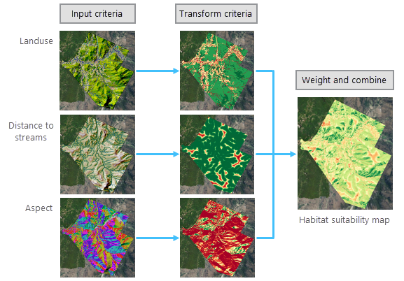
In the habitat submodel, three criteria are transformed, weighted, and combined to create the habitat suitability map. The habitat suitability map identifies the relative preference of each location with respect to the physical conditions for bears to live in. The greener areas are most preferred.
Food submodel
The food submodel identifies the areas where bears have the highest probability of finding food.
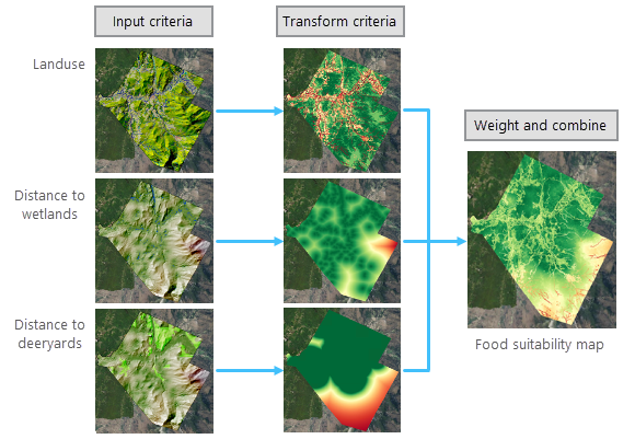
The food suitability map identifies for each location the relative probability for bears to find food. The greener areas have a higher probability of containing food. These areas are in the forests, and closer to wetlands and deeryards.
Security submodel
The security submodel identifies the areas that are the safest for bears.
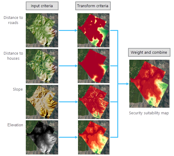
The security suitability map identifies the relative safety of each location for bears. The safest areas are farther away from roads and houses, on steeper slopes, and in higher elevations.
Model of submodels
The resulting suitability maps from each submodel rank the relative preference for each location in regard to the objective of that submodel. The suitability map from the habitat submodel identifies the most preferred areas for bears to live, the food submodel identifies the locations with the most food, and the security submodel identifies the areas that are safest.
The final suitability maps from each submodel are combined in a fourth suitability model.
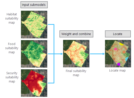
The submodels are weighted and added together to create a final suitability map. The final suitability map identifies for each location how preferred it is while trading off the best areas to live, to find food, and that are the safest.
To identify the actual patches to conserve for bears, the locate step is applied. In addition to the preference for the attributes at each location, bears also have spatial requirements for those attributes. These include how much area bears need, the number of patches required, the shape of the patches, and how far apart the patches should be. The best areas meeting these requirements are determined from the suitability map.
Submodels in the Suitability Modeler
Creating a model in the Suitability Modeler using submodels as input is similar to working with criteria. The main difference is you do not need to transform the input submodels since they are already on a common suitability scale.
When creating the input submodels, use the same suitability scale and weight method (multiplier or percent).
The input submodels may have a different number of criteria. When combining submodels that applied the multiplier weight method, the suitability map from the submodel with the greatest number of criteria will generally be more influential since its range will typically be larger. Adjust the weights of the input submodels to ensure that each influences the final suitability map in the desired manner.
Since you do not need to transform the input submodels, there will be no circle control next to the submodel in the Submodels table on the Suitability tab to open the transformation pane.
As with criteria, to run a model composed of submodels on servers, the input suitability maps from the submodels must be web imagery layers. To generate web imagery layers, when creating each submodel, click the Web imagery layer option when running the suitability map at full resolution. If there are suitability maps from submodels that point to local data, you can use the Sources tab to create web imagery layers of them.
An effective way to work with submodels is to create them in the same Suitability Modeler container (.sam). It is recommended that you give the output suitability maps from each submodel a distinct, meaningful name. However, if you do not rename the maps, the Suitability Modeler will assign unique names.
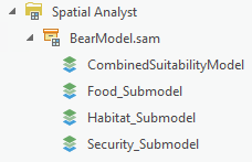
Once the submodels are created, open a new suitability model to combine the submodels. On the Suitability tab, in the Submodel drop-down list, you can select the resulting suitability maps from each of the submodels.
Create a submodel
To create a model that uses the output suitability maps from submodels as input, complete the following steps:
- Create a Suitability Modeler model for each submodel.
- Open a new Suitability Modeler model by doing one of the following:
- If the Suitability Modeler is not open, on the Analysis ribbon, in the Workflows group, click the Suitability Modeler button.
- If the Suitability Modeler is open, on the Suitability Modeler ribbon, in the Suitability Model group, click the New Model button.
- On the Settings tab, specify the name of the model. From the Model input type drop-down menu, choose Submodels.
- On the Suitability tab, enter the final suitability maps created in each of the submodels from step 1 by doing one of the following:
- Click the Add Criteria button
 on the Suitability Modeler ribbon.
 - Click the Add raster submodel datasets by browsing to them button
 on the Suitability tab.
 - Click the Add raster submodels as layers from the Contents list button
 on the Suitability tab.
 - Drag a layer from the Contents pane into the suitability group layer.
- Right-click the suitability group layer and click Add Data
 .
.
- Click the Add Criteria button
- On the Suitability tab, in the Submodels table, weight the submodels relative to one another.
- On the Suitability tab, click Run to create the suitability map at full resolution.
- Specify the spatial requirements on the Locate tab, and click Run to create the locate map.
If the suitability map from a submodel is to be added to the model composed of submodels using the browse button  on the Suitability tab, it must be run at full resolution by clicking Run on the Suitability tab.
A copy of the layer or dataset is made and entered into the model composed of submodels. Any changes made in the submodels will not be reflected in the model of submodels.
The resulting suitability map from step 6 ranks the relative preference for each location while trading off the various objectives of the submodels. The resulting locate map from step 7 identifies the most suitable locations while trading off the objectives and accounting for the subject's spatial needs.
Effect of changing the model input type setting
If Criteria is specified as the Model input type on the Settings tab and you change it to Submodels, the following occur:
- All specified criteria are treated as input submodels as if they were newly entered into the model.
- If any criterion was transformed, the transformed layer is removed from the suitability group layer.
- The suitability map is updated by multiplying each submodel by its weight and adding them together.
If Submodels is specified as the Model input type on the Settings tab and you change it to Criteria, the following occur:
- All specified submodels are treated as input criteria as if they were newly entered into the model.
- You need to transform each criterion and proceed building the model as you would for any model that uses input criteria.