Data Appliance 6.4 for ArcGIS includes the following improvements and enhancements:
Highlights
Data Appliance 6.4 for ArcGIS is delivered on 8-terabyte drives.
Esri Vector Basemaps for ArcGIS Enterprise, an additional set of basemaps in vector tile format, will be available in Spring 2018; it ships separately on a USB flash drive with most product options. The tile layers included with this product provide wider coverage and more up-to-date content than the raster maps provided on Data Appliance 6.4 for ArcGIS.
The World Places Locator is updated on Collection B.
The World Boundaries and Places Alternate service is in mature support and will be retired in the next release of Data Appliance for ArcGIS.
The World_Shaded_Relief service is no longer available on Data Appliance 6.4 for ArcGIS. The service was in mature support in the previous Data Appliance 6.3 for ArcGIS release.
Note:
See ArcGIS Product Lifecycle Support Policy for more information on mature support.
The Data Appliance overview provides information on the different Data Appliance product options and includes a table to help you understand the difference between the services in each product option.
World Imagery
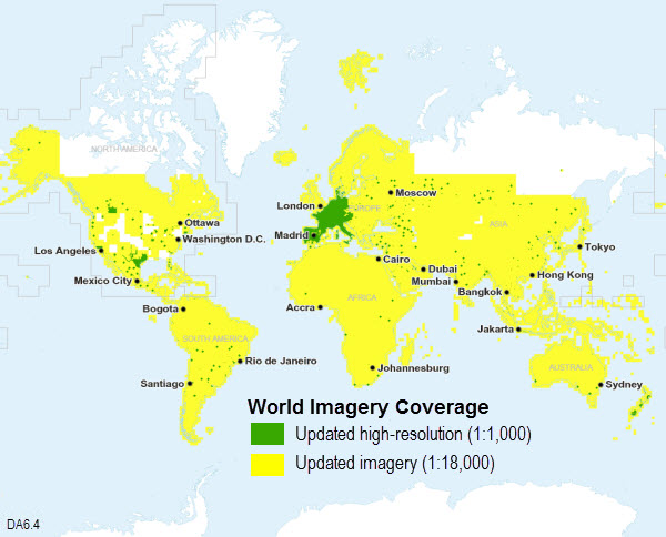
The World Imagery basemap was updated with more recent and more detailed imagery including the following:
- Major content updates from Digital Globe Basemap +Vivid and Basemap +Metro products to over 100 million square kilometers of imagery including about 600 metro areas.
- Major improvements to image currency and quality for most of the world.
- NAIP updates for 22 states with 2016 imagery. The NAIP 2016 imagery includes both 1-meter and 60-centimeter resolution imagery, displayed in the map down to levels 17 and 18, respectively.
License:
Coverage is defined by the product option you licensed.
In addition, community contribution updates include more current and submeter resolution imagery from a number of communities. For a complete list of all contributors, see the list of World Imagery Map Contributors (PDF). Detailed information is available in the World Imagery service description and in the associated metadata layer provided with your source documents.
The following map shows the updated coverage in this release:

See the World Imagery 6.4 coverage maps for more information on the current coverage, and compare them to the World Imagery 6.3 coverage maps.
World Street Map
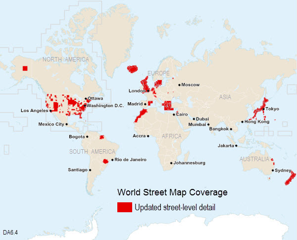
The World Street Map was updated to include authoritative data at the larger scales. There were more than 200 community contributor updates, including nations, states and provinces, and substate (county, city, community) updates. For a complete list of all contributors, see World Street Map Contributors (PDF).
The following map shows the updated street-level coverage in this release:
License:
Coverage is defined by the product option you licensed.
See the World Street Map 6.4 coverage map for more information on the current coverage, and compare it to the World Street Map 6.3 coverage map.
World Topographic Map
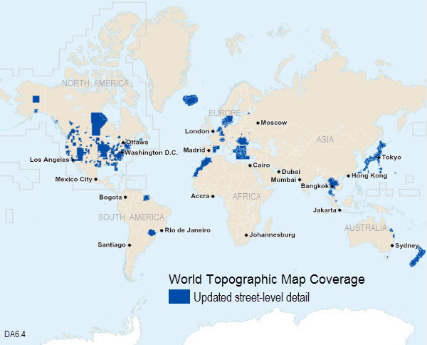
The World Topographic Map was updated to include authoritative data at the larger scales. There were more than 200 community contributor updates, including nations, states and provinces, and substate (county, city, community) updates. For a complete list of all contributors, see World Topographic Map Contributors (PDF).
The following map shows the updated street-level coverage in this release:
License:
Coverage is defined by the product option you licensed.
See the World Topographic Map 6.4 coverage map for more information on the current coverage, and compare it to the World Topographic Map 6.3 coverage map.
World Dark Gray Base and Reference and World Light Gray Base and Reference
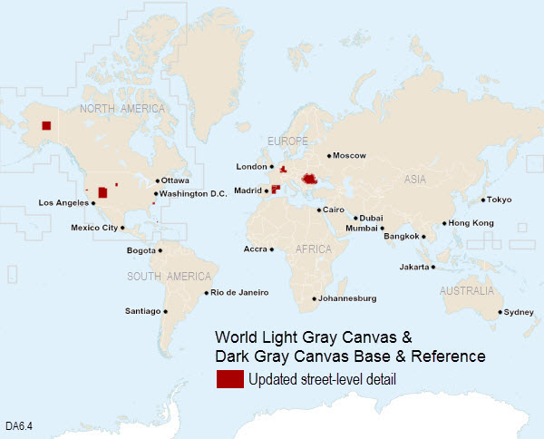
The World Dark Gray Base, World Dark Gray Reference, World Light Gray Base, and World Light Gray Reference maps were updated in select areas of the map. For a complete list of all contributors, see World Canvas Map Contributors (PDF).
The following map shows the updated street-level coverage in this release:

License:
Coverage is defined by the product option you licensed.
See the World Dark Gray Base 6.4 coverage map for more information on the current coverage, and compare it to the World Dark Gray Base 6.3 coverage map.
See the World Light Gray Base 6.4 coverage map for more information on the current coverage, and compare it to the World Light Gray Base 6.3 coverage map.
World Boundaries and Places and World Transportation
The World Boundaries and Places and World Transportation reference layers were updated in select areas of the map. For a complete list of all contributors, view the list of Contributors for the World Boundaries and Places Map (PDF).
License:
Coverage is defined by the product option you licensed.
See the World Boundaries and Places 6.4 coverage map for more information on the current coverage, and compare it to the World Boundaries and Places 6.3 coverage map.
World Boundaries and Places Alternate
The World Boundaries and Places Alternate reference layer is in mature support. This is the last release this service will be included on Data Appliance.
See ArcGIS Product Lifecycle Support Policy for more information on mature support.