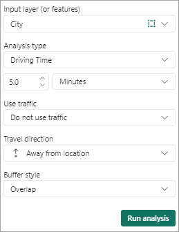
You can create a Buffer/Drive time analysis layer and calculate the time or distance between locations based on parameters such as travel mode, situational traffic, and other variables.
You can create a Buffer/Drive time analysis layer. Review Buffer/Drive time analysis for more information about this analysis layer type that calculates the time or distance between locations based on parameters such as travel mode, situational traffic, and other variables.

Note:
You need to sign in to access the analysis tools.
Analysis types
Note:
The available analysis types options may vary based on your organization's settings. If you don't see a specific analysis type, contact your administrator for more information.
Travel modes and routes obey all local and regional traffic laws such as one-way roads, avoiding illegal turns, and following speed limits. The following Buffer/Drive time analysis types are available:
| Analysis type | Description |
|---|---|
Ring buffer | Uses a straight-line sphere to create a distance buffer around points. |
Driving Time or Driving Distance | Models the movement of cars and other similar small automobiles, such as pickup trucks, and finds solutions that optimize the method of travel time or travel distance. |
Rural Driving Time or Rural Driving Distance | Models the movement of cars and other similar small automobiles, such as pickup trucks, and finds solutions that optimize the method of travel time or travel distance, including travel on unpaved roads. |
Trucking Time or Trucking Distance | Models basic truck travel by preferring designated truck routes and finds solutions that optimize the method of travel time or travel distance. |
Walking Time or Walking Distance | Follows paths and roads that allow pedestrian traffic and finds solutions that optimize the method of travel time or travel distance. The default walking speed is 5 kilometers per hour. |
To create a Buffer/Drive time analysis layer, complete the following steps:
- From the map tools, click Analysis
 .
.The analysis tools appear.
- From the Input layer (or features) drop-down menu, choose where to frame the analysis.
You can use your current location or choose a layer in the map and use the selection tools in the pane to select a location or multiple locations manually. Your current location is based on your system settings.
Note:
Guest users can add a maximum of 5 Buffer/Drive time locations from which to frame the analysis. If you are signed in to your ArcGIS account, you can add a maximum of 10 locations.
Note:
If you styled the map using clustering, you cannot select clustered locations on the map. Change the map style and try again.
- From the Analysis type drop-down menu, choose an analysis type.
Tip:
Guest users can use the Ring buffer and Driving time options. If you are signed in to an ArcGIS account, you can use all the travel mode and time options.
- To use a distance-based analysis, choose Ring buffer, Driving distance, Trucking distance, Walking distance, or Rural driving distance. Set the measurement unit using the drop-down menu and change the distance using the text box or arrow buttons.
- To use a time-based analysis, choose Driving time, Trucking time, Walking time, or Rural driving time. Set the measurement unit using the drop-down menu and change the amount of time using the text box or arrow buttons.
- If you selected Driving time, Trucking time, or Rural driving time, make a selection from the Use traffic drop-down menu to include one of the following:
- Do not use traffic—The default setting. Does not use any traffic conditions.
- Use live traffic—Calculate travel time based on current traffic conditions. Use the slider to offset live traffic conditions up to four hours from the current time.
- Traffic based on typical conditions—Set a day of the week
and time of day on which to base traffic calculations. When adding
time, choose an option from the drop-down menu or add a value
manually. Use the 12-hour or 24-hour time clock. The default value
of 12:00
a.m. is used for invalid time values.
The driving speed and length of time is calculated from a combination of historical and live traffic data.
Tip:
This feature is not available to guest users.
- Choose a Travel direction option from the drop-down menu.
You can calculate time and distance toward or away from the selected input features.
This option is available for all analysis types except the Ring buffer option.
Tip:
This feature is not available to guest users.
- If you selected a travel distance or time, from the Buffer style drop-down menu, choose Overlap or Dissolve.
Overlap
Each feature's resulting geometry is represented as a unique feature.
Dissolve
Overlapping geometries are merged into a single feature.
Tip:
This feature is not available to guest users.
- Click Run analysis.
The results are saved as a new layer on the map and the result layer appears in the Layers list.
Note:
A map can only contain one Buffer/Drive time analysis layer at a time. If a Buffer/Drive time analysis layer already exists, you must delete it before you can create a new one.
- To delete the Buffer/Drive time analysis layer, do one of the following:
- In the Drive Time pane, click Remove analysis.
- From the map tools, click Layers
 to open the Layers list and click More options > Remove
  next to the Buffer/Drive time analysis layer.
Buffer/Drive time measurement units
The following Buffer/Drive time measurement units are used:
| Measurement | Unit | Guest user maximum | ArcGIS account maximum |
|---|---|---|---|
Distance | Meters | 160,934 |
|
Kilometers | 161 |
| |
Feet | 528,000 |
| |
Miles | 100 |
| |
Time | Minutes | 30 | 45 |