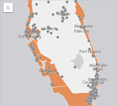


Create a location map to see where your point, line, and area features are located (or alternatively, where features are not located). A location map renders all of the features in a dataset using a single, uniform symbol. Location maps help answer questions about your data, such as: Where is it located? How is it distributed?
Location maps are most useful for datasets where you can see most or all of the features on the map with relatively little overlap. If there are too many point features to distinguish on the map, consider creating a binned map or a heat map.
Example
An insurance company is conducting an assessment to determine how many of its policies are within a storm surge area, and the associated risk. A location map can be used to give the analyst an idea of the number of policies that are in the high-risk area.

The above location map shows customer locations as point features and the storm surge area as area features in the bottom layer. The location map shows that there is a relatively high density of points within the storm surge area compared to the number of points inland.
Create a location map
To create a location map, complete the following steps:
- Do one of the following:
- Drag a dataset to the page and drop it on the Map drop zone.
- Expand the dataset, select the location field
 , drag the field to the page, and drop it on the Map drop zone.
Note:
You can also create a map by selecting a field and clicking the Map button above the data pane.
- If your dataset has a default symbol other than a single symbol, expand the legend to see the Layer options pane, click the Symbology tab
 , and change Symbol type to Location (Single symbol).
Usage notes
The Layer options pane is accessible by clicking the arrow next to the layer name and includes the following configuration options:
- Use the Legend tab
 to view the count of features in the dataset.
 - Use the Symbology tab
 to change the field displayed on the map or switch to a different type of map.
 - Use the Annotation tab
 to disable pop-ups for the layer and enable labels.
 - Use the Appearance tab
 to do the following:
- Symbols—Change the symbol style properties such as the symbol shape, fill color, outline thickness, and layer transparency.
- Layer effects—Enable bloom and drop shadow effects.
- Use the Attributes tab
 to view details for features that are selected on the map.
Click the Flip card button  to turn the map card over. The back of the card includes a count of features and a text box for a description of the map.
Resources
Use the following resources to learn more: