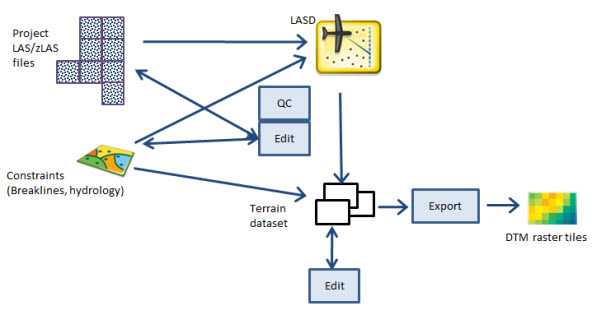
A raster DTM surface can be created based on lidar and other data managed in a terrain dataset. This is a more advanced use case that applies to organizations managing a variety of different authoritative terrain data sources in a geodatabase, for example, to merge model key points from lidar as well as breakline data within a 3D triangulated irregular network (TIN). The terrain dataset allows for versioned management of an authoritative DTM for enterprise use.

A typical use case is the use of lidar data for hydrologic modeling. This workflow may also continue with exporting a DTM raster and adding it into a larger elevation collection, but this will depend on your organization's users and requirements.
This guidebook does not address the numerous design considerations and tradeoffs for building and maintaining your terrain dataset. For more information on this subject, see Terrain dataset in ArcGIS Pro.
The workflow for completing QC using a LAS dataset is described above in Manage lidar collections with LAS datasets. Following QC, your lidar data should be integrated into your authoritative terrain dataset according to your existing procedures. If you want to export a DTM from the terrain to be merged with other elevation surfaces, proceed below.
- Run the Terrain To Tiled Rasters tool (essentially the same as LAS Dataset To Tiled Rasters) using the settings identified during QC, or possibly modified based on the characteristics of your terrain dataset.
- Enter an appropriate cell size for your full-resolution DTM.
- Enter the pyramid resolution for the highest resolution from the terrain pyramid level that will be used to generate output rasters. The default is 0, or full resolution.
After exporting the DTM in one or more files, follow Elevation best practices.