Listed below are questions or issues you may encounter when working with Data Appliance 6.4 for ArcGIS content as well as recommended solutions.
- How does Data Appliance for ArcGIS work?
- How do I set up Data Appliance for ArcGIS?
- Where does the data come from?
- What services are available?
- Are there any use restrictions when using services?
- Why am I encountering an error when publishing Data Appliance 6.4 services on ArcGIS Server 10.3, 10.3.1, 10.4, or 10.4.1?
- Can I view the metadata for a service?
- Why are my map services missing some tiles at certain levels of detail?
- Why does the image quality of the 2D services seem to vary in ArcMap?
- How do I configure my server to display a Map Data Not Available tile?
Data Appliance for ArcGIS contains maps that you can publish on ArcGIS Server. The maps have been cached at a set of fixed scale levels for optimum performance. Once you publish these maps to your GIS server, you can use them in any ArcGIS Server client application, such as ArcMap, or web and mobile mapping apps. See Use services for more information.
You set up Data Appliance for ArcGIS by connecting the appliance to your GIS server and publishing the appliance's maps through ArcGIS Server. The service definitions you'll need to publish, as well as their associated map caches, are included with each Data Appliance for ArcGIS data collection.
There is a quick-start guide for your configuration included in the Data Appliance for ArcGIS box. You can also view the quick-start guides online.
If you've published an ArcGIS Server service previously, you may find this process familiar. If you're new to publishing services or working with ArcGIS Server, you'll find instructions in Deploy Data Appliance on ArcGIS Server.
The content used with Data Appliance for ArcGIS is the same content you see online, with some minor exceptions. A complete list of data sources is included with the description for each service. See the Directory of maps and data for a list of services.
For a complete list of available services, see the Directory of maps and data.
The data is provided by multiple third-party data vendors under license to Esri for inclusion in Data Appliance for ArcGIS for use with Esri software. Redistribution rights are granted by Esri and the data vendor for hard-copy renditions or static, electronic map images (for example, .gif and .jpg) that are plotted, printed, or publicly displayed with proper metadata and source or copyright attribution to the respective data vendor or vendors. For copyright and attribution information, see the service description for a specific map service in the Directory of maps and data.
Yes. For information on viewing metadata, see one of the following metadata topics:
- Metadata for services in the ArcGIS Server 10.6 help under Publishing services > How to publish services
- Metadata for services in the ArcGIS Server 10.5 help under Publishing services > How to publish services
- Metadata for services in the ArcGIS Server 10.4 and 10.4.1 help under Publishing services > How to publish services
- Metadata for services in the ArcGIS Server 10.3 and 10.3.1 help under Publishing services > How to publish services
In certain cases, when you upgrade Data Appliance from one version to the next, the new service or services may not recognize all of the new content available on the new version of Data Appliance. You can resolve this by rebooting the machine where ArcGIS Server is installed after you delete all of the services from the previous Data Appliance version.
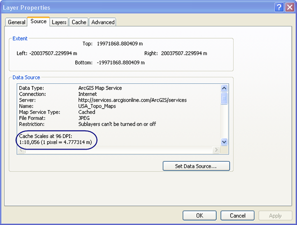
Data Appliance for ArcGIS uses a set of map images cached at certain scale levels. As you zoom to different scales in ArcMap, ArcMap displays the map image that corresponds to the closest cached scale level to what you're viewing. The image is then resampled to fit the scale you're viewing in ArcMap. Consequently, the clarity of some features and labels from Data Appliance for ArcGIS will vary as you change scale levels in proportion to the degree of resampling taking place. You will achieve the most clarity at or around the scales at which the services were cached. You can view a list of these scale levels on the Source tab of the Layer Properties dialog box for each service.
