The Extract Features Using AI Models tool extracts features of interest from imagery using pretrained AI models. The AI models can either be ArcGIS pretrained models from ArcGIS Living Atlas of the World or custom deep learning model packages (.dlpk). The tool accepts imagery and allows you to choose from several pretrained Object Detection or Pixel Classification models that can extract features from the imagery. Several models can be chosen to extract multiple features of interest. In addition to detecting features and classifying pixels in the imagery, the tool optionally performs postprocessing on the output to generate refined results. It is also possible to only postprocess previously generated results using this tool. The tool creates a group layer containing all the extracted features.
Tool
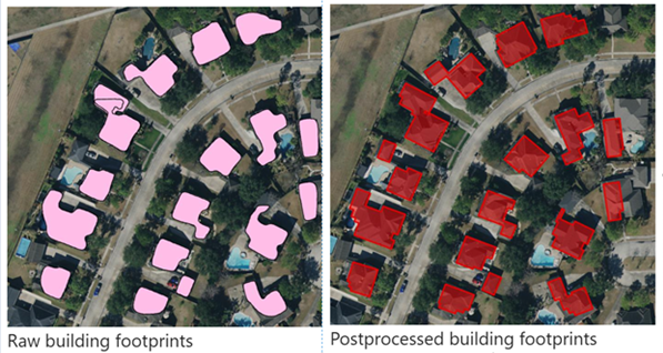
The Extract Features Using AI Models tool accepts overhead imagery and an area of interest as its input. The tool then determines the type of imagery, the number of bands, and the spatial resolution of the imagery and recommends a list of ArcGIS pretrained models from ArcGIS Living Atlas of the World that can be used on the provided raster. One or more models can be selected, and you can also browse to your own deep learning model packages (.dlpk) that you have available on disk. The models are then used to perform inferencing over the input imagery to extract features from all the models in a single run of the tool. Often, the results from deep learning models must be postprocessed to get a refined result. For instance, in the following example, the extracted building polygons must be regularized to have a rectilinear shape, and segmented roads or parcel boundaries must be vectorized and refined before they are finished.

The tool automatically performs postprocessing steps for ArcGIS pretrained models. These postprocessing workflows can also be used with other compatible models trained using ArcGIS. This allows generation of refined results without running multiple geoprocessing tools.
Postprocessing workflows are available for line and parcel regularization, as well as for polygon regularization. Lines and parcel regularization work with single-band rasters with binary classification, and polygon regularization only works with polygon features. These aspects must be considered while applying postprocessing on additional models. The tool requires 3D Analyst, Spatial Analyst, and Production Mapping extension licenses to run the postprocessing workflows. If any of these extensions are not available, the postprocessing steps will be skipped and only the raw output will be generated by the tool.
The inference options provided by the tool are shared during the inference of all the models (including pretrained and additional models). For example, when using a value of 0.8 as the threshold, this value is used as the confidence threshold during the inference of all the models in the current run of the tool. Similarly, if multiple models use a specific postprocessing workflow, the same postprocessing parameters are used by all the models.