| Label | Explanation | Data Type |
Input Features
| The input line or polygon features. | Feature Layer |
Output Feature Class
| The output feature class containing the densified geodesic features. | Feature Class |
Geodetic Type
| Specifies the type of geodetic segments that will be created. Geodetic calculations are performed on the ellipsoid associated with the input data's coordinate system.
| String |
Distance
(Optional) | The distance between vertices along the output geodesic segment. The default value is 50 kilometers. | Linear Unit |
Summary
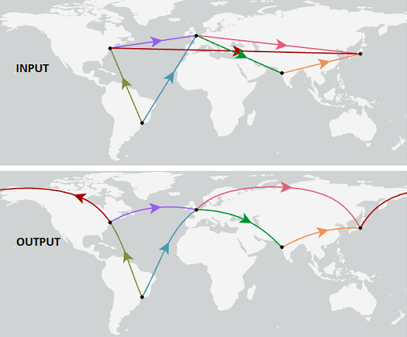
Creates new features by replacing the segments of the input features with densified approximations of geodesic segments. The following types of geodesic segments can be constructed: geodesic, great elliptic, loxodrome, and normal section.
Illustration

Usage
The end points of the segments will be connected using a geodetic approximation. The input segment type is irrelevant; linear and nonlinear (circular arc, elliptic arc, and Bezier curve) segments with common end points will produce the same output.
No output feature will be written for an input feature that consists of a single segment with coincident start and end points. For example, a polygon feature made of a single circular arc will not be written to the output.
Parameters
arcpy.management.GeodeticDensify(in_features, out_feature_class, geodetic_type, {distance})| Name | Explanation | Data Type |
in_features | The input line or polygon features. | Feature Layer |
out_feature_class | The output feature class containing the densified geodesic features. | Feature Class |
geodetic_type | Specifies the type of geodetic segments that will be created. Geodetic calculations are performed on the ellipsoid associated with the input data's coordinate system.
| String |
distance (Optional) | The distance between vertices along the output geodesic segment. The default value is 50 kilometers. | Linear Unit |
Code sample
The following Python window script demonstrates how to use the GeodeticDensify function in immediate mode.
import arcpy
arcpy.management.GeodeticDensify(r"C:\data.gdb\flight_lines",
                                 r"C:\data.gdb\flight_lines_geodesic",
                                 "GEODESIC")