Available with Network Analyst license.
This help topic provides information on how live traffic works. It covers OpenLR live traffic and TMC live traffic. For an overview of traffic, see What is traffic data.
OpenLR live traffic
OpenLR is an open standard for live traffic feed data. The network can be configured to download OpenLR traffic feed data and associate it with network elements using network source feature geometry and attributes.
Learn more about OpenLR
To create a working live-traffic network dataset configured for OpenLR, the following are required:
- Access to a portal configured with live traffic.
- Historical traffic data must be set up on the network dataset.
- The appropriate network attributes for Functional Road Class, Form of Way, Travel Direction, and Length.
- A network with a prepopulate cache.
- A time zone table, which must be stored in the same geodatabase as the network dataset you are working with. A time zone network attribute is created to get information from this table.
Configure OpenLR live traffic
Configure OpenLR live traffic by completing the following steps:
- Open the network dataset properties dialog box and click Traffic > Live Traffic.
- Ensure your active portal is configured with live traffic
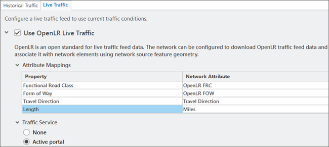
- Check the Use the OpenLR Live Traffic check box to display the OpenLR properties that can be configured on a network dataset that supports live traffic.
- Map the OpenLR properties to their corresponding network dataset attributes as in the table below:
- Click the Active portal button and apply the changes by clicking OK.
OpenLR live traffic is configured and ready to be used while running a network analysis.

| Property | Explanation | SMP attribute |
|---|---|---|
Functional Road Class | Road classification based on the importance of a road See the OpenLR technical paper for allowed values and their definition. | OpenLR FRC |
Form of Way | Physical road type See the OpenLR technical paper for allowed values and their definition. | OpenLR FOW |
Travel Direction | A network attribute that defines the allowed direction of travel along each street segment | Travel Direction |
Length | Distance with units defined | Miles or Kilometres |
OpenLR live traffic workflow
When performing a network analysis, the traffic feed specified in the active portal is used to get the current live traffic values. These values are combined with the internal cache to create an interim cache that relates the element IDs directly to the speed values.
The traffic evaluator has fallback logic to determine what speed value to use if a live traffic speed value is not found. Learn more about edge traffic evaluator.
If there is a problem accessing the traffic feed, the network analysis output will include a warning message.
TMC live traffic
TMC (Traffic Message Channel) is a standard format for live traffic feed data. The network dataset can be configured to download TMC live traffic feed data and associate it with network elements using a Streets-TMC table.
To create a working TMC live-traffic network dataset, the following are required:
- Access to a live traffic feed.
- Historical traffic data must be set up on the network dataset.
- A Streets-TMC table, which must be stored in the same geodatabase as the network dataset you are working with.
- A time zone table, which must be stored in the same geodatabase as the network dataset you are working with. A time zone network attribute is created to get information from this table.
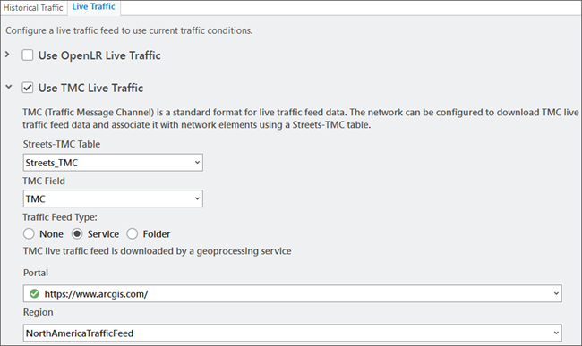
Check the TMC Live Traffic check box to display the TMC properties that can be configured on a network dataset that supports live traffic. 
TMC live traffic workflow
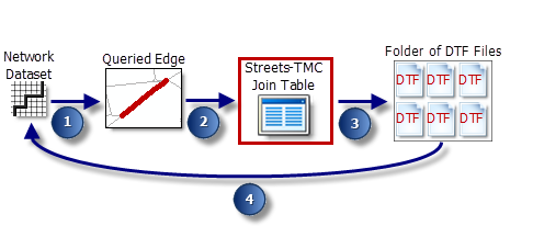
The network dataset reads live traffic speeds from dynamic traffic format (DTF) files and relates the speeds to edges using traffic message channel (TMC) codes. TMC codes are standard unique identifiers that are supported by various organizations, including traffic data providers. The following graphic and the text below illustrate and describe this process:
The network dataset queries an edge for the current travel time. This occurs when a network analysis layer is being solved or when traffic is being drawn on a map.
The identifying source feature information (source feature class, source feature, and from-to and to-from positions) is used to look up one or more TMC values. The lookup is performed with the information that was in the Streets-TMC Table at the time of the last network build. The Streets-TMC Table relates streets to TMC codes.
Dive-in:
The red box around the Streets-TMC Join Table in the diagram is there to highlight an oversimplification of the diagram. A network dataset doesn't directly reference the join table during the query process; that would be too slow. Instead, the information in the join table is built into the network dataset and referenced internally for faster processing. Consequently, any changes you make to the Streets-TMC table won't be incorporated into the network until it is rebuilt.
The network dataset looks for a DTF file, which is a binary file designed for network datasets, and reads the travel speed information. On the Live Traffic tab, you can specify the folder where the downloaded DTF files reside by clicking the browse button for the Folder option; or use the Service option to use the live traffic feeds from ArcGIS Online or an Enterprise portal which has a proxy to ArcGIS Online.
Each DTF file is marked with a valid time range and contains TMCs and their corresponding travel speeds for the given time span. The network dataset opens a DTF file only if the time and date for which the edge is being queried is within the DTF file's valid time range. In many cases, multiple DTF files have valid time ranges that are within the queried time. This can occur when live traffic includes traffic predictions of a given depth, for example, for the next 12 hours. If multiple, valid files exist for the queried time, the file that was created immediately before the queried time is opened.
Dive-in:
Only one DTF file is opened per solve. That is, if multiple, valid files exist, only one is used throughout the duration of that solve process. Whenever the solver queries an edge for a time and date outside the file's time range, it attempts to retrieve the travel time from historical traffic tables instead.
Once the DTF file is opened, the TMC and its associated travel speeds are combined with the length of the queried edge to determine the actual travel time.
If a valid TMC value or DTF file can't be found, the network dataset falls back to historical traffic to retrieve the travel time. If historical travel times don't exist, it falls back to either a weekend- or weekday-specific network cost attribute, depending on the day of the week for which the edge is being queried. This fallback sequence is set out in the edge traffic evaluators of the traffic-based cost attribute.
Streets-TMC table
The Streets-TMC table furnishes the information needed to relate edges to speed values that are stored in DTF files. Typically, this table is provided by a data vendor along with street data.
The table below lists the required fields of a Streets-TMC table, an example field name, the allowed data types, and a short description.
Note:
The Network Analyst tutorial data, which is available on ArcGIS.com, includes a San Diego network dataset with a Streets-TMC table for your reference. After downloading and extracting the data, you can find the SanDiego geodatabase at \Network Analyst\Tutorial\SanDiego.gdb.
| Field | Field name example | Data type | Description |
|---|---|---|---|
Edge feature class identifier | EdgeFCID You must name this field EdgeFCID. | Long integer | Identifies the feature class that stores the street feature. |
Edge feature identifier | EdgeFID You must name this field EdgeFID. | Long integer | Identifies the street feature. |
Edge from position | EdgeFrmPos You must name this field EdgeFrmPos. | Double | Works in conjunction with EdgeToPos to identify a direction of travel or side of the street. Zero indicates the beginning of the line feature as defined by its digitized direction. One indicates the opposite end. For example, an EdgeFrmPos value of 0 and an EdgeToPos value of 1 identifies travel in the digitized direction of the line feature. The TMC value listed in the same record represents that side of the street only. Any decimal values specify a position along the digitized direction of the feature, which allows the Dissolve Network tool to maintain the proper TMC values for streets after edges have been dissolved together. |
Edge to position | EdgeToPos You must name this field EdgeToPos. | Double | Works in conjunction with EdgeFrmPos to identify a direction of travel or side of the street. |
TMC code | TMC | String | The TMC code representing the associated road segment. |
Traffic feed type
You can select the source of live traffic to be used in your analysis by choosing one of the following options:
- None—Live traffic is not used during the analysis.
- Service—Access the traffic data service from ArcGIS Online or from your ArcGIS Enterprise portal configured to use this service. Access to this service is restricted to use with the ArcGIS StreetMap Premium dataset and requires the Live Traffic extension for your ArcGIS Online organization. In the Portal drop-down list, you will find all managed portals. Each portal has an icon next to it indicating a status.
- Green—The portal can obtain and return the live traffic helper service URLs and has no traffic feed authorization-related problems.
- Yellow—The network dataset has previously been updated to use a service. The organization of the signed-in user at that time was authorized to use traffic feeds. However, the organization of the currently signed-in user is not authorized at this time to use traffic feeds on this portal.
The following are examples:
- The organization of the currently signed-in user is not authorized for traffic. The signed-in user might have been for a different organization of the portal that is authorized. Or alternatively, it could be the same organization but they are no longer authorized for traffic feed service.
- The portal was previously set up, but the user is not currently signed in to the portal, so it cannot be used as an authorization portal for traffic feed.
- Red—The portal is not currently authorized for traffic feeds and cannot be chosen for authorization.
The following are examples:
- The portal is not licensed to use live traffic.
- The enterprise portal's traffic data service has not been set up to come from ArcGIS Online. You can set up traffic data service for your enterprise portal using the Configure Traffic Data Service dialog box.
- Folder—Choose this option to identify the folder where DTF files are downloaded. The path to the folder can be a local file system path or a Universal Naming Convention (UNC) path.
Modify live traffic
Follow the steps below to modify a network's live traffic settings:
- Open the Network Dataset Properties dialog box.
- Click Traffic.
Two tabs, Historical Traffic and Live Traffic, appear. However, if the network dataset you're using was not configured to support traffic at the time it was created, these tabs will be unavailable.
- Click the Live Traffic tab and check the Use TMC Live Traffic check box.
- From the Streets-TMC Table drop-down list, choose the Streets-TMC table.
If your geodatabase does not have a valid Streets-TMC table candidate, the drop-down list will be empty.
DTF files created from traffic feeds store travel-speed information by TMC code. The Streets-TMC table relates TMC codes to street segments or subsections of street segments so that travel speeds can be linked ultimately to network edges. The Streets-TMC table is often included with network data acquired from a data vendor.
Learn more about the schema and attributes of a Streets-TMC table
- From the TMC drop-down list, choose the field in the Streets-TMC table that contains TMC codes.
- Depending on the source you want to use for live traffic feeds, choose from the following options: Service or Folder.
The path to the folder can be a local file system path or a UNC path.
Note:
You can set up the ArcGIS StreetMap Premium network dataset's live traffic from an ArcGIS Enterprise portal on a network dataset property page live traffic tab. The ArcGIS Enterpriseportal's live traffic service can be set up to come from ArcGIS Online using the new Configure Traffic Data Service dialog box.
Considerations
Consider the following when you are using OpenLR and TMC live traffic:
- OpenLR live traffic can only be used in ArcGIS Pro 3.2 or later.
- TMC live traffic should be configured if the network is to be used in earlier versions of ArcGIS Pro.
- OpenLR and TMC live traffic can both be configured at the same time on a network dataset.
- Configuring OpenLR live traffic is encouraged if the network is capable of supporting OpenLR and it will be used in ArcGIS Pro 3.2 or later.
- StreetMap Premium network datasets can be configured to use OpenLR live traffic when they meet the specified requirements.