Note:
If you're looking for what's new in the latest release of Collector, see What's new.
21.0.3 (iOS)
The release of Collector 21.0.3 on iPad and iPhone includes the following:
- Various bug fixes and improvements.
21.0.2 (iOS)
The release of Collector 21.0.2 on iPad and iPhone includes the following:
- Various bug fixes and improvements.
21.0.1 (iOS)
The release of Collector 21.0.1 on iPad and iPhone includes various bug fixes and improvements, including the following:
20.2.4 (iOS)
The release of Collector 20.2.4 on iPad and iPhone includes various bug fixes and improvements, including the following:
20.2.3 (iOS)
The release of Collector 20.2.3 on iPad and iPhone includes the following:
- Various bug fixes and improvements, including the following:
20.2.2 (iOS)
The release of Collector 20.2.2 on iPad and iPhone includes the following:
- Collector for ArcGIS renamed to ArcGIS Collector.
- Various bug fixes and improvements.
20.2.0 and 20.2.1 (iOS)
The Collector 20.2.0 and 20.2.1 releases on iPad and iPhone bring a number of enhancements and bug fixes, including the following:
- Attach PDF, Excel, and Word documents to assets or observations.
- Reuse list entries between forms.
- Capture additional metadata when collecting using the GPS.
- Use app links to update existing feature attributes.
- Various bug fixes and improvements, including the following:
20.2.1 (Android)
The release of Collector 20.2.1 on Android includes the following:
- Collector for ArcGIS renamed to ArcGIS Collector.
- Various bug fixes and improvements.
20.2.0 (Android)
The release of Collector 20.2.0 on Android brings a number of enhancements and bug fixes, including the following:
20.1.0 (Android)
The release of Collector 20.1.0 on Android is a major update bringing the app closer to equivalency with the iOS app.
It includes support for a number of map improvements available to ArcGIS organizations and modernizes the app. You'll see improved forms, support for map areas defined as part of the map, new tools, and support for 3D data collection. In addition, linking to the app has a new format and is more powerful. The release is a complete refresh of the app, and along with it, the original Collector app was renamed Collector Classic.
Better-looking, more performant maps
Create great-looking maps in your portal and open them in Collector. Use vector basemaps and view crisp, high-quality cartography that takes advantage of the pixel density of high-end mobile devices. The rich symbology you rely on to effectively represent your spatial information looks great in Collector, including symbol effects you publish through ArcGIS Pro. Labels (including using Arcade expressions), the top idea requested for Collector, are also supported. With this release, your maps perform and look better than ever, even rotated.

User experience updates
A key element of the release is the overall design. The user interface has been redesigned for simplicity and consistency.
Better use of screen space
Use the screen more efficiently to get the most out of your device. On a phone, you no longer have to choose between looking at the map and looking at the form for your asset or observation while you are collecting data. When you start collecting, the form uses half the screen, and the map uses the other half. If you're focusing on the form, expand the panel to use the full screen.
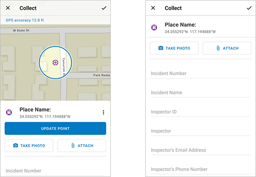
Location target
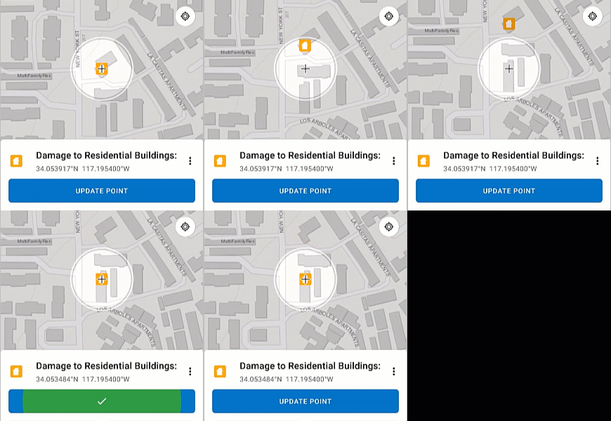
During collection, a location target helps you precisely place points. Manually adding points on the map (either as the location of a single place or to build the location of a length of area) no longer means obscuring the part of the map you're interested in with your finger. Using this targeting approach, crosshairs on the map now mark where each point is placed. Use the GPS or pan and zoom the map to position points and see where you'll be placing the data while you're placing it.
Common tasks at your fingertips
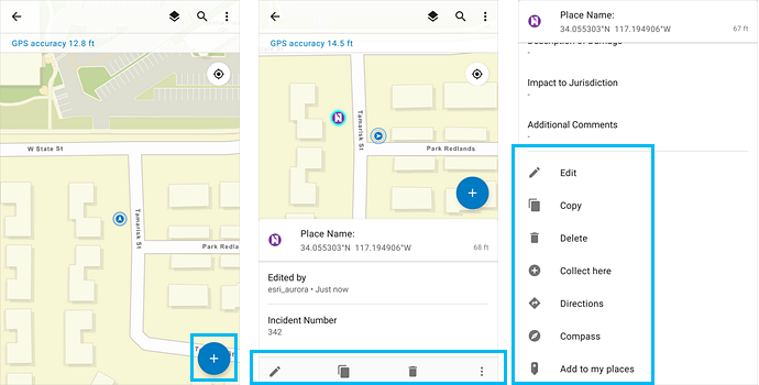
When you're ready to collect data, you can now add an asset or observation from a button promoted onto the map and near where you hold your device.
If you're not collecting a new asset or observation, but working with an existing one, those tasks have been promoted, too. Whether you need to edit or copy a feature, use the new compass tool to get to it, or get directions, the tasks you need are available.
Improved forms
Forms have both functional and user experience improvements, including the following:
- Arcade expression support—You can use Arcade attribute expressions to calculate entries based on formulas and other parts of the form. For example, you can do unit conversion and include trailing text to show units, combine multiple entries for a more intuitive read, or specify a custom format. See Calculate title or entries using Arcade expressions.
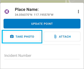
- Faster access to the camera—It used to take two taps to launch the camera; now it takes only one. Once you take a picture, you see a preview, accept it, and continue to your next task.
- Additional attachment support—In addition to images, you can now attach videos.
- Data entry enhancements—Read information from QR codes and barcodes, edit entries in place on the form, and use a proper keyboard when editing numeric entries.
New, streamlined offline workflows
Collector still supports taking maps offline to work in areas without a reliable data connection. In the app, mobile workers can still define map areas to take offline. In addition, map authors can now create map areas as part of the map so that mobile workers in Collector can download them without having to configure the areas themselves.
The map author can specify the basemap to use offline as part of authoring the map in ArcGIS Online or ArcGIS Enterprise 10.7 or later. When the mobile worker downloads a map area (either defined as part of the map or defined in the app) with that basemap package already on the device, the basemap isn't downloaded. See Reference an on-device basemap.
Additional offline workflow improvements include support for automatically syncing changes, taking multiple areas of a single map offline, and downloading vector tile basemaps to use less space on the device than comparable raster basemaps.
New tools
You'll now find a legend and improved navigation in Collector. The legend is part of the Layers tool  .
.
Working in the field, you might be near your asset or observation but not at the exact location. Now you can use the Compass  (available in the asset or observation's Overflow menu
  ) to get to where you need to be. The map orients itself in the direction you are facing, and a guideline shows the direction to the asset or observation you need to find.
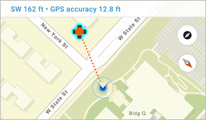
If you are not close to your asset and need to
navigate streets to get there, use Directions  (also available in the asset or observation's Overflow menu
  )
before you use the compass. You can choose which
navigation app you want to use for directions: Google Maps or ArcGIS Navigator—use the one that works for
you.
3D data collection
Previously, Collector didn't record z-values (altitude information). With this release, it does, and you can directly capture 3D data to use throughout ArcGIS.
Open Collector through new links and with new parameters
Provide your mobile workers with a link they can click to open Collector, use a particular portal, or do a particular task within the app (such capturing an asset). While some of this functionality was available through the Collector URL scheme, the new links use HTTPS instead of a custom URL scheme, making them more reliable.
The new links support all the functionality you used in the Collector URL scheme, including opening a map, centering it, and starting to capture assets and observations. In addition, the new links support providing the URL to the portal the mobile worker must connect to.
See Open your map from a link for details on the links and parameters, including some examples.
Side by side with Collector Classic
The original Collector app has been renamed Collector Classic on Google Play. Both Collector and Collector Classic can be installed on the same device, preventing disruption of your existing workflows and allowing you to transition to the new app as your organization is ready to do so. However, future development work is focused on the new app.
20.1.0 (iOS)
The release of Collector 20.1.0 on iPad and iPhone is an exciting one, bringing commonly requested functional improvements, including the following:
- Snapping
- Updating the form of multiple assets, observations, or inspections
- Using recent values
- Providing a portal URL through a barcode or QR code
- Viewing your tracks from ArcGIS Tracker
In addition, the release brings a number of enhancements and bug fixes.
Snapping
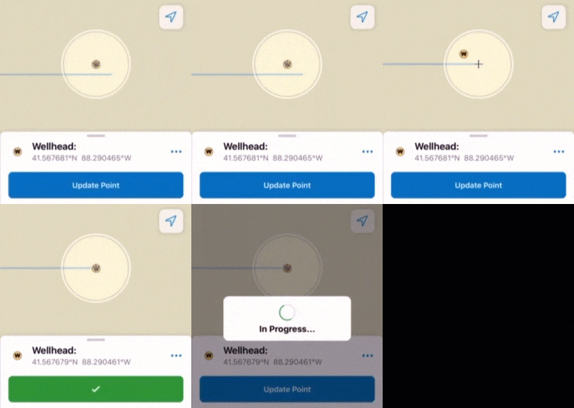
When using the map to provide the location of an asset during data collection, mobile workers can snap to existing points—either single places or a point that is part of a line or polygon. This allows them to make sure that your assets and observations that share locations are correctly captured.
By default, snapping is enabled. You can turn it off. For details, see Snap to existing locations.
Bulk form updates
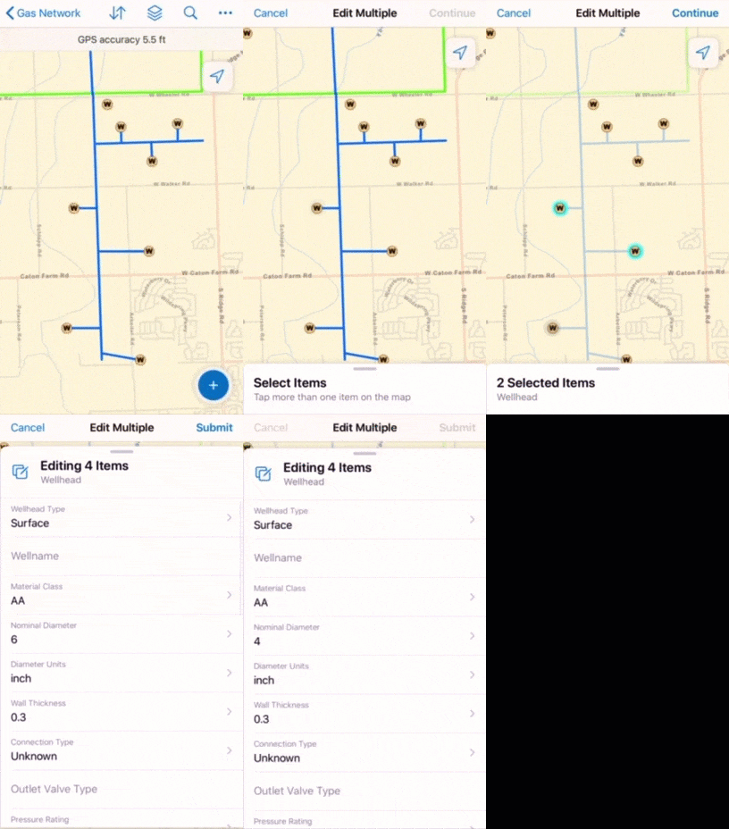
Update a form entry for multiple assets or observations at the same time. For example, if mobile workers are performing inspections and need to mark multiple hydrants as having passed inspection, they can select all of them and update all their form entries tracking inspection at once. For details, see Update the forms of multiple existing assets.
Recent values
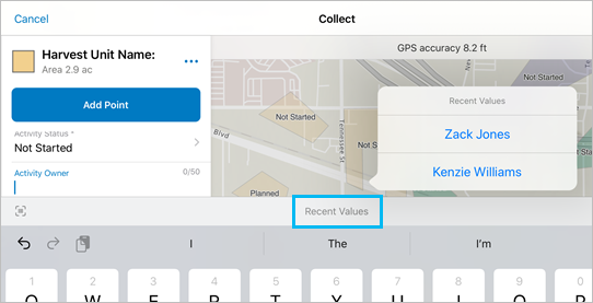
Easily reuse field entries between forms, minimizing repetitive data entry tasks. When mobile workers go to another form after completing one, they can select from their recent entries to populate the new form. For details, see Reuse recent values.
Scan portal URL
Make it easier for mobile workers to enter the portal URL by providing a barcode or QR code that they can scan to start signing in. For details, see Sign in.
Tracks from Tracker
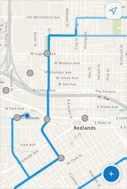
Mobile workers can view their tracks from ArcGIS Tracker even before they are uploaded to your organization. Collector can now access and display the tracks stored locally on the device, allowing a mobile worker to see where they've been throughout their data collection, allowing them to make sure they covered the required areas. For details, see Is location tracking supported in Collector?.
Various bug fixes and improvements
This release also includes various bug fixes and improvements, including the following:
- Updated the look and feel of the app to take advantage of the available screen space on iPhone X or later, as well as the clean icons and menus in iOS 13.
- Lists of assets and observations tapped on the map are grouped into sections by layer.
- Layers and Legend are now separate, and Layers
 is available from the main toolbar.
 - The customizable field guide template has been updated with the changes to Layers and Legend, along with how to enable logging.
- Dual XGPS160 and Juniper Systems Geode receivers are now supported.
- Use a magnifier to drop a pin by long pressing on the map.
- Information about past editing of an asset or observation only displays if the pop-up is configured to include it.
- The Imagery Hybrid basemap now renders correctly when taken offline in newer maps.
- BUG-000119720
- BUG-000119842
- BUG-000120942
- BUG-000121419
- BUG-000121739
- BUG-000122051
- BUG-000123493
- BUG-000123963
- BUG-000126956
- BUG-000127285