| Etiqueta | Explicación | Tipo de datos |
TIN de entrada | El dataset TIN que se procesará. | TIN Layer |
Clase de entidad de salida | La clase de entidad que generará. | Feature Class |
Campo de código (Opcional) | El nombre del campo en la clase de entidad de salida que define el tipo de línea de corte. El nombre de campo predeterminado es Código. | String |
Resumen
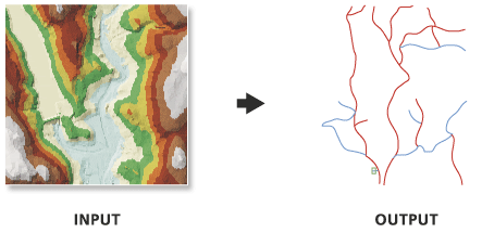
Exporta líneas de corte desde un dataset de red irregular de triángulos (TIN) a una clase de entidad de línea 3D.
Ilustración

Uso
Las líneas de salida se atribuyen con valores enteros que identifican cada tipo de línea de corte. Estos códigos se almacenan en un campo cuyo nombre lo define el parámetro Campo de código, y el significado de los valores se define a continuación:
- 1—Línea de corte fina, que representa los cambios graduales en la pendiente.
- 2—Línea de corte gruesa, que representa los cambios abruptos en la pendiente.
El TIN debe tener líneas de corte para que esta herramienta produzca entidades de línea. Si se desea obtener los bordes del triángulo, independientemente de las líneas de corte, considere la posibilidad de usar la herramienta Arista del TIN.
Parámetros
arcpy.ddd.TinLine(in_tin, out_feature_class, {code_field})| Nombre | Explicación | Tipo de datos |
in_tin | El dataset TIN que se procesará. | TIN Layer |
out_feature_class | La clase de entidad que generará. | Feature Class |
code_field (Opcional) | El nombre del campo en la clase de entidad de salida que define el tipo de línea de corte. El nombre de campo predeterminado es Código. | String |
Muestra de código
En el siguiente ejemplo se muestra cómo usar esta herramienta en la ventana de Python.
arcpy.env.workspace = 'C:/data'
arcpy.ddd.TinLine('tin', 'tin_line.shp', code_field='BreakType')En el siguiente ejemplo se muestra cómo usar esta herramienta en una secuencia de comandos independiente de Python.
"""****************************************************************************
Name: Create Terrain from TIN
Description: This script demonstrates how to create a terrain dataset using
             features extracted from a TIN. It is particularly useful in
             situations where the source data used in the TIN is not available,
             and the amount of data stored in the TIN proves to be too large
             for the TIN. The terrain's scalability will allow improved
             display performance and faster analysis. The script is designed
             to work as a script tool with 5 input arguments.
****************************************************************************"""
# Import system modules
import arcpy

# Set local variables
tin = arcpy.GetParameterAsText(0) # TIN used to create terrain
gdbLocation = arcpy.GetParameterAsText(1) # Folder that will store terran GDB
gdbName = arcpy.GetParameterAsText(2) # Name of terrain GDB
fdName = arcpy.GetParameterAsText(3) # Name of feature dataset
terrainName = arcpy.GetParameterAsText(4) # Name of terrain

try:
    # Create the file gdb that will store the feature dataset
    arcpy.management.CreateFileGDB(gdbLocation, gdbName)
    gdb = '{0}/{1}'.format(gdbLocation, gdbName)
    # Obtain spatial reference from TIN
    SR = arcpy.Describe(tin).spatialReference
    # Create the feature dataset that will store the terrain
    arcpy.management.CreateFeatureDataset(gdb, fdName, SR)
    fd = '{0}/{1}'.format(gdb, fdName)
    # Export TIN elements to feature classes for terrain
    arcpy.AddMessage("Exporting TIN footprint to define terrain boundary...")
    boundary = "{0}/boundary".format(fd)
    # Execute TinDomain
    arcpy.ddd.TinDomain(tin, tinDomain, 'POLYGON')
    arcpy.AddMessage("Exporting TIN breaklines...")
    breaklines = "{0}/breaklines".format(fd)
    # Execute TinLine
    arcpy.ddd.TinLine(tin, breaklines, "Code")
    arcpy.AddMessage("Exporting TIN nodes...")
    masspoints = "{0}/masspoints".format(fd)
    # Execute TinNode
    arcpy.ddd.TinNode(sourceTIN, TIN_nodes)
    arcpy.AddMessage("Creating terrain dataset...")
    terrain = "terrain_from_tin"
    # Execute CreateTerrain
    arcpy.ddd.CreateTerrain(fd, terrainName, 10, 50000, "",
                            "WINDOWSIZE", "ZMEAN", "NONE", 1)
    arcpy.AddMessage("Adding terrain pyramid levels...")
    terrain = "{0}/{1}".format(fd, terrainName)
    pyramids = ["20 5000", "25 10000", "35 25000", "50 50000"]
    # Execute AddTerrainPyramidLevel
    arcpy.ddd.AddTerrainPyramidLevel(terrain, "", pyramids)
    arcpy.AddMessage("Adding features to terrain...")
    inFeatures = "{0} Shape softclip 1 0 10 true false boundary_embed <None> "\
             "false; {1} Shape masspoints 1 0 50 true false points_embed "\
             "<None> false; {2} Shape softline 1 0 25 false false lines_embed "\
             "<None> false".format(boundary, masspoints, breaklines)
    # Execute AddFeatureClassToTerrain
    arcpy.ddd.AddFeatureClassToTerrain(terrain, inFeatures)
    arcpy.AddMessage("Building terrain...")
    # Execute BuildTerrain
    arcpy.ddd.BuildTerrain(terrain, "NO_UPDATE_EXTENT")
    arcpy.GetMessages()

except arcpy.ExecuteError:
    print(arcpy.GetMessages())
except Exception as err:
    print(err)