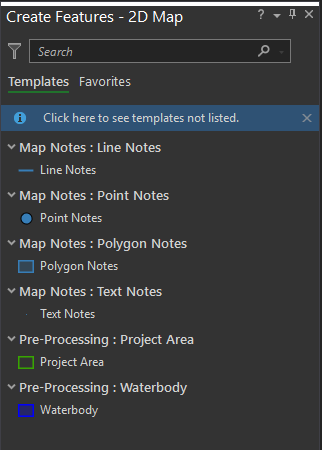
The features that a feature template creates are determined by the data source for the layer or layers it references. In ArcGIS Drone2Map, the only editable layers are in the Pre-Processing and Map Notes groups in the Contents pane. Drone2Map supports the creation of 2D features on all layers in the Map Notes group and only polygon features in the Pre-Processing group layers.
2D features store x- and y-coordinates with their geometry. Although 2D features do not inherently store z-values, you can display them in 3D space by deriving z-values from an elevation surface.
Create a feature
In Drone2Map, new features are created in the Create Features pane.
To create a new feature, complete the following steps:
- On the Edit ribbon, click the Create button.
- In the Create Features pane, click the layer you want to edit.

An edit session is automatically initiated and features can now be created.
- Click the Save button on the Edit ribbon to save your edits.
- Close the Create Features pane when you finish editing.
Feature types
Choosing which feature type to create depends on the objects or data points you intend to represent, the information you need to capture, and the type of analysis for which they will be used. In some scenarios, you may need to create more than one feature type for the same data.
Point features
Point features identify specific x,y,z coordinate locations on a map. You can create objects or data points that don't require lines or areas to store information or convey meaning. Examples include utility poles, water hydrants, and trees.

Polyline features
Polyline features consist of straight line segments and freehand digitization. You can create linear and curvilinear objects that have length but no area. Examples include water supply lines, roads, and streams.

Polygon features
Polygon features are fully enclosed areas bounded by straight line segments, circular arcs, elliptical arcs, and freehand drawn vertices. You can create objects that have closed planar regions. Examples include lakes, vegetation boundaries, and building footprints.

Text notes
Text notes are text strings associated with a point feature. They can be placed as a point, at the end of a line, or along the sides of a feature. Examples include building names, road names, and city or location names.
