Some of the new feature highlights of Drone2Map 2022.1 are described below.
New processing and product creation engines
A new processing engine, nFrames, has been implemented within the Drone2Map 2022.1 software. The new engine combines with the existing Esri AT (Aerial Triangulation) framework to offer larger project processing and improved point cloud generation. Areas of the user interface have been updated to accommodate this change.
The point cloud products now generated by Drone2Map are significantly more detailed than previous versions, allowing for improved definition of vegetation and manmade features. The improved detail also helps 3D mesh layers look more realistic when imagery is draped over the surfaces.


Redesigned multispectral camera support
A new multispectral project template has been added to Drone2Map 2022.1. The software will automatically switch to this multispectral template when you import imagery from a supported multispectral camera.
In addition to the new template, radiometric correction can now be performed through the Radiometric Calibration button located on the Flight Data tab. This process supports the use of radiometic calibration panels to adjust each band and provide a radiometrically corrected orthomosaic.


© AgEagle Sensor Systems Inc., d/b/a MicaSense. (2021) MicaSense Altum Complete Flight sample data. Retrieved from https://micasense.com/sample-data-altum/
Thermal processing capabilities with Radiometric JPEG support
R-JPEG imagery can be processed in Drone2Map 2022.1. When adding the imagery to the New Project window, the software will automatically detect the R-JPEG format and set the project template to the Thermal Template. After processing the thermal orthomosaic, a color ramp is applied as well as a scale in degrees Celsius or Fahrenheit.
New image status for improved processing feedback
An uncalibrated status has been added to the images layer in the Contents pane. This allows for a quick and easy diagnosis of which images have, or have not, been calibrated after the Adjust images step has been run.

Pre-processing tools added for quality control
A new toolset has been added to the Home tab for refining flights before processing.

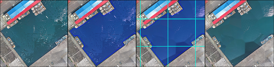
The Waterbody Mask tool allows you to draw or import a polygon area that defines the water bodies within your flight area. The areas within the mask are then interpolated during processing to provide improved water reconstruction.
The Project Area tool allows you to draw or import a polygon area that defines a processing boundary for the project. The tool is particularly useful when working with oblique imagery or flights with low overlap where confidence in coverage at the flight boundaries may be questionable. The resulting products are processed up to the defined Project Area.
The Correction Feature tool allows you to draw or import a polygon that defines an area you would like to re-process or correct reconstruction issues. Buildings and features within a projects flight area may be poorly reconstructed when there are sub-optimal flight conditions. This tool lets you correct that by drawing a polygon over the features and reprocess the product. The end result is a cleaner reconstruction of the area. Correction features can be made in 2D or 3D and will honor the z value of each vertex when making modifications to orthomosaic products.

Re-processing with tile based workflows
Drone2Map orthomosaic products by default are generated as tiles and mosaicked together. The allows you to perform corrections on a tile by tile basis. The Waterbody Mask and Correction Feature tools are honored when you re-process orthomosaic products. This means that you can process an orthomosaic, review it for quality issues, then define polygon features with either tool to quickly correct those issues. When you re-process only the tiles that overlap the polygon features are updated which saves time and allows for improved quality control of outputs.
SLPK clipping now supported
The clip toolset has been extended for use with scene layer packages. You can now apply a clipping area for 3D products after it has been generated.
SLPK meshes now support projected coordinate systems
Scene layer package meshes can now be projected into any of the supported coordinate systems within Drone2Map. If your project is in a projected coodinate system, then the output SLPK will be in that given system. This helps save some post-processing steps that were previously needed in previous versions of the software.
Vertical coordinate system support has been expanded
Drone2Map 2022.1 now fully supports all the same geographic and vertical coordinate systems as ArcGIS Pro: supported coordinate systems
Create and share animations of your 2D and 3D products
You can now compose the same professional animations in Drone2Map as you can in ArcGIS Pro. The functionality is similar between the software applications and adds convenience for quick demonstrations or detailed overviews. Animation tools work in either 2D maps or 3D scenes.

Redesigned Edit Camera Pane
The Edit Camera portion of the software has been updated for a more streamlined workflow, and appear in its own integrated pane. You can still manually define camera parameters, or choose from a pre-existing database of supported cameras.

Offline documentation
One big advantage of Drone2Map is that you can take it offline and into the field. However, if you need a quick software reference or are a new user testing the software, then there was no way to see our documentation without an internet connection. We now have an offline help installer for Drone2Map 2022.1 that will stay current with each release. It is also translated into many of the languages that we currently support.
