This FAQ section provides answers to commonly asked questions about this solution.
- How are road closures modeled?
- Can I track closures caused by construction, special events, and emergency incidents?
- How do I ensure that I closed the right road?
- What if I do not know when the road closure will end?
- Can I map a recurring road closure?
- Can I map a partial road closure?
- Can I map a road closure that impacts one direction of travel?
- How do I specify that an intersection is open to through traffic?
- How do I specify that an intersection is closed to through traffic?
- How do I specify specific lanes of travel at an interchange, or intersection are closed to through traffic?
- How do I specify a road is closed for an emergency incident?
- Do I need to add blocks at each intersection?
- How can I share my road closure data with consumer mapping companies?
- Which consumer mapping applications is Esri partnering with?
- Do I need to use the Road Closures solution to participate in Esri Community Maps?
- Can I modify the Road Closures layers and still participate in Esri Community Maps?
- How frequently is road closure data aggregated?
- How is road closures data licensed and shared?
- Will the detour routes that I map be used by consumer mapping applications to route traffic?
- Will every closure I map be visible in consumer mapping applications?
- Can I access the Community Maps aggregated feed?
Yes, there are two methods that can be used to map a recurring road closure. You can create a unique feature for the first road closure and populate the appropriate attribution. Then select the closure, click copy, and paste to create each recurring closure. Once you have created all the recurring closures, update the start and end dates and times on each closure. You can also map the initial road closure, populate the start and end date and time and then routinely update the start and end dates and times.


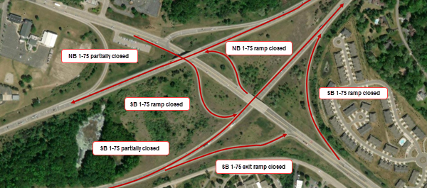
To specify a road is closed for an emergency incident, create a new closure feature for each impacted road. Ensure the Reason field is set to Hazard, the Active Incident field is set to Yes, and a description of the emergency incident is provided in the Description field. Verify all other required fields are also correctly populated.
Deploy the Road Closures solution and use it to map closures in your community. When your organization is ready to share road closures with residents and visitors, you can join Esri Community Maps and share your road closure information with Esri with consumer mapping companies that partner with Esri.
To share the same closure information with Waze and Google Maps, you must join the Waze for Cities program and register your closure layer in the Waze Partner Hub.
Esri is building partnerships with several leading consumer mapping applications. Multiple partnerships means that your authoritative data can be accessed by a larger number of residents, commuters, travelers, and so on. A current list of partners can be found here.
Yes, the Community Maps aggregated feed can be accessed by Community Maps Contributors that are actively sharing road closure data for use by Esri and it's partners. Access is granted for use within a respective ArcGIS Online organization, public sharing is not allowed. Visit the ArcGIS Marketplace for more details.