| Operand | Explanation | Data Type |
in_raster_or_constant | The input raster to be negated (multiplied by -1). | Raster Layer | Constant |
Summary
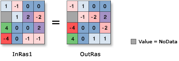
Changes the sign of the cell values (multiplies by -1) of the input raster on a cell-by-cell basis.
Illustration

Discussion
When using an operator with a raster input, the result will be a raster. However, if all inputs are numbers, the result will be a number.
When there are multiple operators in an expression, the operators are not necessarily run in left-to-right order. The operator with the highest precedence value will be run first. For more information, see the operator precedence table in Work with operators in map algebra. Use parentheses to control the run order.
If the input is integer, the output will be integer. If the input is floating point, the output will be floating point.
If the input is a multiband raster, the output will be a multiband raster. The operator will perform the operation on each band in the input.
If the input is a multidimensional raster, all slices from all variables will be processed, and the output will be a multidimensional raster.
Parameters
Code sample
This sample changes the sign of the values in the input raster.
import arcpy
from arcpy import env
from arcpy.sa import *
env.workspace = "C:/sapyexamples/data"
outNegate = - Raster("degs")
outNegate.save("C:/sapyexamples/output/outneg")This sample changes the sign of the values in the input raster.
# Name: Op_Negate_Ex_02.py
# Description: Changes the sign (multiplies by -1) of the cell values
#              of the input raster on a cell-by-cell basis
# Requirements: Spatial Analyst Extension

# Import system modules
import arcpy
from arcpy import env
from arcpy.sa import *

# Set environment settings
env.workspace = "C:/sapyexamples/data"

# Set local variables
inRaster = Raster("degs")

# Execute Negate
outNegate = -(inRaster)

# Save the output
outNegate.save("C:/sapyexamples/output/outnegate")