Available with Image Analyst license.
Overview
Computes various synthetic aperture radar (SAR) indices for SAR data, such as Radar Vegetation Index (RVI), Radar Forest Degradation Index (RFDI), and Canopy Structure Index (CSI).
The formulas that are used for these indices depend on the polarizations available in the input radar dataset. This function reads the input radar data and determines the appropriate polarization to use for the selected index formula and the available polarization bands.
Notes
The input radar data must be in linear units. If the radar data is in dB units, use the Unit Conversion function to convert the radar data from dB to linear units.
For the RFDI and RVI indexes, cities, deserts, and water bodies can have values corresponding to barren, degraded, and deforested landscapes, since little or no vegetation is inherent to these regions.
When the Index parameter value is RVI or RFDI and the input data is quad-pol, the quad-pol algorithm will be used in the index computation. To use the dual-pol RVI or RFDI algorithms with quad-pol data, use the Extract Bands function first. RVI requires HH, HV; VV, VH; or HH, HV, VH, VV polarizations. RFDI requires HH, HV or VV, VH polarizations. CSI requires HH, VV polarizations.
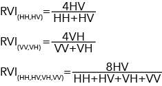
The possible equations for RVI are  .
.
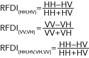
The possible equations for RFDI are  .
.
The equation for CSI is  .
.
Parameters
| Parameter | Description |
|---|---|
Raster | The input radar data. |
Index | Specifies the SAR index that will be computed. This parameter dynamically updates based on the input radar data. CSI will only be listed if the input radar data contains HH and VV bands.
|