| Label | Explanation | Data Type |
Input Features
| The input polygon features that will be used to generate the cartogram. | Feature Layer |
Field Name | The numeric field containing the values that will determine the area of the polygon features in the output cartogram. Any features with a negative value or a value of 0 will be omitted from the output. | Field |
Output Feature Class
| The output polygons with the cartogram transformation applied. | Feature Layer |
Method (Optional) | Specifies the method that will be used to transform the input and create the cartogram.
| String |
Summary
Generates a cartogram by distorting the area of polygons to be proportional to each other based on a numeric field while preserving shared boundaries.
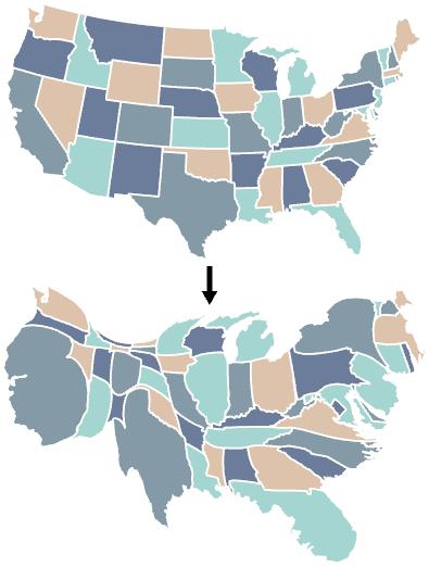
Illustration

Usage
The output will be a new polygon feature layer with the polygons transformed so that the area of each feature is proportional to the value of a numeric field compared to the sum of that field across all features in the input.
The input layer's attribute data will be transferred to the output. Symbology and labeling will be transferred when the input is a symbolized layer.
The Method parameter has the following options:.
- Flow-Based—This option is an evolution of the Diffusion method and is often faster. The shape of the output polygons may be different or contain slightly more distortion in comparison. This is the default.
- Diffusion—This option may introduce slightly less distortion to the original shapes than the Flow-Based option while taking longer to complete.
To decrease the processing time, you can run the Simplify Polygon tool on the input features before running this tool. This may result in some output polygons appearing oversimplified if they are distorted to be significantly larger.
The input data or the active map displaying the data should use an equal area projection appropriate for that region. This is so the visible area of the input polygons will more accurately represent the actual area before being modified. Use the Cartographic Coordinate System environment if there is no active map and the data uses a nonequal area projection. Display the results in the same equal area projection for an accurate depiction of the adjusted feature areas.
The field values in the Field Name parameter value should be positive numbers. Any features with negative or 0 values will not be present in the output.
Additional resources:
Gastner, Michael T. and M. E. J. Newman. 2004. "Diffusion-based method for producing density-equalizing maps." Proceedings of the National Academy of Sciences of the United States of America, 101(20): 7499–7504.
Gastner, Michael T., Vivien Seguy, and Pratyush More. 2018. "Fast flow-based algorithm for creating density-equalizing map projections." Proceedings of the National Academy of Sciences of the United States of America, 115(10): E2156-E2164.
Parameters
arcpy.cartography.GenerateContiguousCartogram(in_features, field_name, out_features, {method})| Name | Explanation | Data Type |
in_features | The input polygon features that will be used to generate the cartogram. | Feature Layer |
field_name | The numeric field containing the values that will determine the area of the polygon features in the output cartogram. Any features with a negative value or a value of 0 will be omitted from the output. | Field |
out_features | The output polygons with the cartogram transformation applied. | Feature Layer |
method (Optional) | Specifies the method that will be used to transform the input and create the cartogram.
| String |
Code sample
The following Python window script demonstrates how to use the GenerateContiguousCartogram function in immediate mode.
import arcpy
arcpy.env.workspace = "C:/data/admin.gdb"
arcpy.cartography.GenerateContiguousCartogram(
    "countries",
    "population",
    "countries_cartogram_population",
"FLOW-BASED")The following stand-alone script demonstrates how to use the GenerateContiguousCartogram function.
# Name: GenerateContiguousCartogram_sample2.py
# Description: Output a contiguous cartogram of country polyons
#              based on popuplation.

# Import System Modules
import arcpy

# Set environment settings
arcpy.env.workspace = "C:/data/admin.gdb"

# Set Local Variables
in_features = "countries"
value_field = "population"
out_cartogram = "countries_cartogram_population"
algorithm = "DIFFUSION"

# Execute Generate Contiguous Cartogram
arcpy.cartography.GenerateContiguousCartogram(
    in_features,
    value_field,
    out_cartogram,
    algorithm)