| Label | Explanation | Data Type |
Input Features | The building polygons to be simplified. | Feature Layer |
Output Feature Class | The output feature class to be created. | Feature Class |
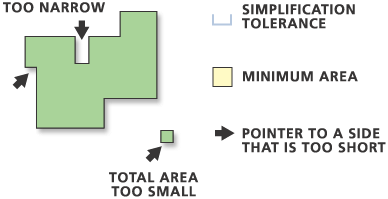
Simplification Tolerance | The tolerance for building simplification. A tolerance must be specified, and it must be greater than zero. You can choose a preferred unit; the default is the feature unit. | Linear Unit |
Minimum Area (Optional) | The minimum area for a simplified building to be retained in feature units. The default value is zero, that is, to keep all buildings. You can specify a preferred unit; the default is the feature unit. | Areal Unit |
Check for spatial conflicts (Optional) | Specifies whether spatial conflicts—that is, overlapping or touching among buildings—will be identified. A SimBldFlag field is added to the output to store conflict flags. A value of 0 means no conflict; a value of 1 means conflict.
| Boolean |
Input barrier layers
(Optional) | The input layers containing features to act as barriers for simplification. Resulting simplified buildings will not touch or cross barrier features. For example, when simplifying buildings, the resulting simplified building areas do not cross road features defined as barriers. | Feature Layer |
Derived Output
| Label | Explanation | Data Type |
| Polygons Collapsed To Zero Area | The output point feature class that will store points that represent buildings that are removed because they are smaller than the Minimum Area parameter value (minimum_area in Python). This parameter is only used when the Keep collapsed points parameter is checked (collapsed_point_option = "KEEP_COLLAPSED_POINTS" in Python). | Feature Class |
