You are sharing a scene that includes a new web elevation layer. The elevation source is a raster dataset that either does not have pyramids or the pyramids have not been built completely.
Solutions
- Calculate raster pyramids for your raster dataset using Build Pyramids.
More information
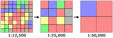
Pyramids are designed to speed up the display of raster data. They work by retrieving a level of resolution that is appropriate for a given map scale. When zoomed in to a small area, pyramids retrieve and display highly detailed data. Zooming out to successively larger areas causes them to retrieve and show less detailed data, which reduces data transfer and drawing times. Although the level of detail is reduced when viewing larger areas, it often isn't visibly noticeable.
