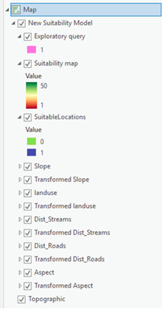
The suitability group layer in the Contents pane stores the model base criteria, the transformed criteria, the final suitability map, the locate layer, and the query layer.

Create a suitability group layer
When the Suitability Modeler is first opened, a new suitability group layer is added to the Contents pane.
- Open the Suitability Modeler.
- In ArcGIS AllSource, on the Analysis tab, click the Suitability Modeler button
 .
. - On the Suitability ribbon, click the New Suitability Model button
 .
. - In the Catalog pane, right click a suitability model container
 , click New, and click Suitability Model.
- In ArcGIS AllSource, on the Analysis tab, click the Suitability Modeler button
- Do any or all of the following to add criteria to the model:
- Click the Add Criteria button
 on the Suitability ribbon.
 - Click the Add raster criteria as layers from contents button
 or the Add raster criteria dataset by browsing button
  in the Criteria table on the Suitability tab.
 - Drag a layer from the Contents pane into the suitability group layer.
- Right-click the suitability group layer and click the Add Data button
 .
.
- Click the Add Criteria button
Suitability group layer actions
When you click the circle button next to a criterion on the Suitability tab, the corresponding transformed layer for the criterion is added to the suitability group layer. The button turns green indicating it is the active criterion in the Transformation pane. The button turns grey when the criterion has been transformed and is no longer the active criterion.
The final suitability map layer is added to the suitability group layer once the first criterion is added to the model and its transformed criterion is generated.
The Locate layer that identifies the ideal locations for sites or preservation areas is added to the suitability group layer when you click Run on the Locate tab.
A query layer is added to the suitability group layer once a query expression is specified and applied on the Suitability tab.
Work with the layers in the suitability group layer
Any of the layers in the suitability group layer can be displayed in a map in ArcGIS AllSource in the same way as other layers. Whenever there is a change to the applied transformation of a criterion, the corresponding transformed and final suitability map layers are updated.
The transformed and suitability map layers are calculated at screen resolution and the extent of the display using raster functions. These layers are calculated at the source resolution and full extent when the model is run on the Suitability tab. The Locate layer is always calculated at full resolution.
The transformed layers are not saved to disk by default. To save individual layers, check the Save transformed dataset when model is run check box in the Transformation pane and specify a path and name for the output transformed criterion dataset. The identified transformed dataset is created and saved when the model is run locally at full resolution.
The suitability layer is saved to the location specified on the Settings tab when the model is run locally at full resolution. The Locate layer is saved to the name and location specified on the Locate tab. When running the model on servers, the suitability and locate maps are saved as web imagery layers on the server with the specified names, followed by the time they were created.
Remove layers
To remove a layer and its corresponding transformation layer from the model and the suitability group layer, do one of the following:
- On the Suitability tab, click the Parameters tab. In the Criteria table, in the Input Rasters column, place the pointer in the row of the layer to remove. Click the Remove the criterion button
 .
. - In the Contents pane, in the suitability group layer, right-click the base criterion, and click Remove.
- In the Contents pane, select the base criterion and drag it out of the group layer.