Round Down (Spatial Analyst)

Available with Spatial Analyst license.

Summary

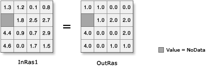
Returns the next lower integer value, just represented as a floating point, for each cell in a raster.

Illustration

Round Down illustration
OutRas = RoundDown(InRas1)

Usage

  • Input values can be positive or negative.

  • The output raster from this tool is always floating-point type, regardless of the input value type.

  • If the input number has any values to the right of the decimal point, the output will be assigned the next lower integer value, but will be represented as a floating point number with no decimal portion. For example:

        Input   Output
         5.3     5.0
         4.9     4.0
         3.0     3.0
         6.5     6.0
        -0.2    -1.0
        -2.8    -3.0
  • If the input is a multiband raster, the output will be a multiband raster. The tool will perform the operation on each band in the input.

  • If the input is multidimensional raster data, all slices from all variables will be processed. The output will be a multidimensional raster in CRF format.

Parameters

LabelExplanationData Type
Input raster or constant value

The input values to be rounded down.

To use a number as an input for this parameter, the cell size and extent must first be set in the environment.

Raster Layer; Constant

Return Value

LabelExplanationData Type
Output raster

The output raster.

The cell values are the result of rounding down the input values.

Raster

RoundDown(in_raster_or_constant)
NameExplanationData Type
in_raster_or_constant

The input values to be rounded down.

To use a number as an input for this parameter, the cell size and extent must first be set in the environment.

Raster Layer; Constant

Return Value

NameExplanationData Type
out_raster

The output raster.

The cell values are the result of rounding down the input values.

Raster

Related topics