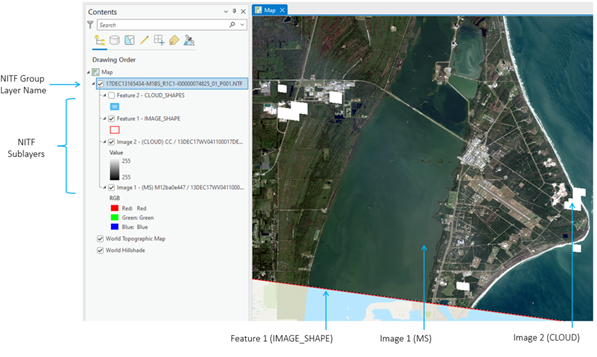
When you add a NITF file to a map, ArcGIS constructs a special NITF group layer that represents the entirely of a data product, including primary and ancillary data contained within the NITF file.

Note:
In the example above, a WorldView-3 8 Band MSI basic level 1b image product is displayed with the ancillary data representing both image footprint and clouds and individual feature layers in the Contents pane. Also listed in the Contents pane is Image 2 – (CLOUD) CC /, representing cloud cover as a raster layer. The primary image is Image 1 – (MS), the 8-band multispectral image. Together they are represented as a single logical group, conveniently providing additional contextual information that can be used as needed when exploiting the primary image.
The NITF layer may contain a variety of sublayers with data types that represent the full view of a given data product in a single logical grouping, in which each data type is represented as a sublayer, such as a raster and feature table. Sublayers can be managed independently of the other layers and be used individually as inputs into geoprocessing workflows.
The NITF layer name uses the value in the NITF FTITLE field by default. The field can contain up to 80 characters in length. If the FTITLE field is not available in the NITF layer, the label uses the file name.
Each image sublayer is labeled with three parts, which correspond to the ICAT, IID1, and IID2 fields. Each feature sublayer is labeled using the SHAPE_USE field in the Data Extension Segment (DES). All image and feature sublayers in the file are supported and listed in the Contents pane, as well as in the Catalog pane when the NITF container is expanded.