GeoPlanner allows you to import existing point, line, and polygon features that are shared to your ArcGIS organization into scenarios to create plans and designs from a known baseline. You can then use the baseline to compare before-and-after scenarios and visualize the impacts of proposed designs with ArcGIS GeoPlanner dashboards.
Note:
If you are sharing a web map from ArcGIS Pro to import it as a feature layer in an GeoPlanner project, check the Use symbol types compatible with all clients check box. This will convert ArcGIS Pro symbols to web symbols that can be rendered by all applications, including older clients. If unchecked, some symbols may not render which will adversely affect custom symbology and layer colors.
There are multiple ways to import features to a scenario. The import function outlined in the steps below allows you to map source feature types to target feature types. For example, you can use the import function to add agricultural data to a GeoPlanner scenario in a project created with the GeoPlanner template for land-use planning. Features that represent fruit are mapped to the target scenario labeled for Agricultural Orchard, and source features that represent grain are mapped to the Agricultural Crop target feature type. You can also import attribute values associated with geometries to a target scenario. If your project feature service has default values configured for one or more attributes, those values are imported to the target scenario.
Note:
After source feature types have been mapped to target feature types, you can edit the values for individual target feature types, but you can't edit how the source and target features are mapped.
Once you have imported features into a scenario, you can do any of the following:
- Create, edit, or delete features.
- Visualize feature summaries in dashboard charts and indicators.
- Run analysis tools in the Analyze category on the Explore tab to understand the design's impact.
- Save the scenario that contains the imported features as a new scenario.
Tip:
You can also import data layer features to a scenario by clicking Options  on a feature layer in the Data Layers section of the Contents pane and choosing Add to Design Layers. You can import a maximum of 10,000 polygons, 15,000 lines, and 25,000 points to a scenario per design layer.
Import features into a scenario
Feature layers brought into a project must be added as data layers before they can be used as design layers in a scenario. Once the feature layers are added to the project, you can import them to a specific scenario.
Note:
Layers cannot be grouped.
- Open a project in GeoPlanner.
- On the Explore tab, click Add Data and add one or more feature layers to a project in GeoPlanner.
You can also publish features and add files from your computer to import file-based datasets, such as geodatabase feature classes or shapefiles.
Note:
You can import feature layers with the following geometry type values:
- esriGeometryPolygon
- esriGeometryPolyline
- esriGeometryPoint
Feature layers with an esriGeometryMultipoint geometry type cannot be imported. You can view a feature layer's geometry type and value by navigating to the item's URL from your ArcGIS organization and clicking All Layers and Tables.
The feature layers appear in the Data Layers section in the Contents pane.
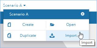
- Click the scenario drop-down arrow and click Import.

- On the Import Features to Scenario dialog box, click the Source drop-down arrow and choose the data layer you added.
The number of features to be imported appears. This figure changes as filters are added.
- Click the Target drop-down arrow and choose a scenario layer.
- Click the Scenario drop-down arrow and choose a scenario.
- Check the Filter by current map extent check box to only import features within the extent of the active map.
- Check the Filter by value check box to only import features that contain a specific field with a specific value.
The drop-down options to specify a field and corresponding value only appear when the Filter by value check box is checked. Depending on your screen resolution, you may need to scroll down on the Import Features to Scenario dialog box to review the number of features to be imported and to access the Filter by current map extent and Filter by value check boxes.
- Click Next.
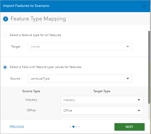
- Choose whether to specify a feature type for all of the features or a field that contains feature type values for features.

- If you chose Select a feature type for all features, click the Target drop-down arrow and specify a target feature to import all source features into as a single target feature type.
- If you chose Select a field with feature type values for features, complete the following steps:
- Click the Source drop-down arrow and choose a source field to map source features to specific target features.
Source Type and Target Type columns appear under the Source drop-down list.
- Choose a Target Type feature for each Source Type feature.
- Click the Source drop-down arrow and choose a source field to map source features to specific target features.
- Click Next.
- Optionally, choose a target field from the drop-down menu for each source field.
You can only map source fields to target fields that do not result in data loss or truncation. For example, you can only map source double fields to target double fields. The following is a list of allowed field mappings:
Source field type Target field types Date
Date
Double
Double
Float
Double, Float
GlobalID
GlobalID
GUID
GUID
Long
Double, Float, Long
ObjectID
Long
Short
Double, Float, Long, Short
Text
Text
- Click Next.
- Check the Import scenario features in the background check box to perform the import in the background.
- Click Import.
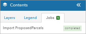
The Import Features to Scenario dialog box closes. A notification appears on the Jobs tab in the Contents pane when the feature import is complete.

Tip:
The number of completed jobs appears on the Jobs tab in the Contents pane.
- If necessary, click the scenario drop-down arrow and choose the scenario you specified as the target.
The imported features appear as part of the scenario.
Import a single feature to a scenario layer or a study area
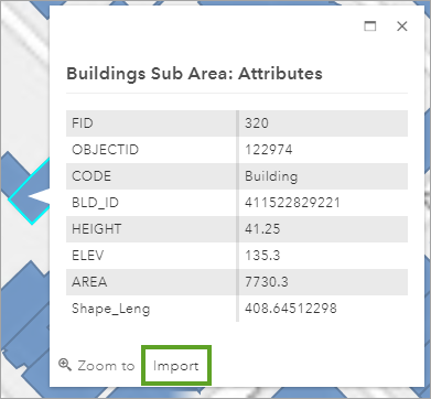
GeoPlanner allows you to import a single feature from its pop-up window. The pop-up window in GeoPlanner includes an Import option for feature layers. Complete the following steps to import a single feature into a scenario layer or study area:
- On the Explore or Evaluate tab, click the feature that you want to import into a scenario or study area.
A pop-up window appears.
- Click Import.

- Click the Layer drop-down arrow and choose StudyArea to import the feature as a study area in the active project.
- Alternatively, choose a design layer to import the feature to a scenario design layer.
- Provide a name for the study area.
- If you specified a design layer in the previous step, click the Type drop-down arrow and specify a design layer type for the imported feature layer.
- Click Import.
The feature is imported to the study area. If you specified a design layer, the feature is imported to the scenario as a design layer.