Note:
A new Collector app is available. For help with the new app, see Quick reference.
Extend the reach of ArcGIS to your field work force and use Collector for ArcGIS to improve the accuracy and currency of your spatial data. Using your ArcGIS organizational account, you can create and configure maps that tailor Collector for ArcGIS to fit your workflow needs.
The main parts of the app are as follows:
Tip:
While this topic presents an overview of the main app screens, you should focus on the collection workflow the app facilitates. For data collection, see Collect data. To work with your data, see Create and share a map for data collection. To record routes of collectors using the app, see Track where collectors go.
Map
The majority of your time in the app is spent interacting with the map, where a basemap and features display. This is the active open map and is the map used in your data collection. When viewing the map, you can collect data, get directions, begin measuring, and initiate all the other capabilities of the app. Use the Map Gallery to open a map.
Note:
The app opens to the most recently viewed map if there is one; otherwise, it opens to the Map Gallery.

Note:
The map has a measure mode that is used to measure distances and areas on the map. In that mode, the available tools, as well as the behavior of the map, are different. While viewing an open map, using the map highlights features and presents information about them. In measure mode, using the map adds vertices and updates the measurement.
Similarly, the map has a collection mode that is used to collect a new feature or edit the attributes of an existing feature. In that mode, the tools and behavior of the map are also different. See the below section, Collect screen, for details.
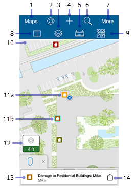
The following are highlighted in the previous image of the map:
- Maps—Goes to the Map Gallery.
- My Location tool—Uses GPS to show your location on the map. The icon changes to show the state of the GPS. The icon
 indicates your location does not display on the map. Once your location is turned on, the icon
  indicates your location displays on the map and is kept centered. As you move, the map moves on the screen to keep your location centered on the screen. Once you pan the map while your location displays, the icon
  indicates your location displays on the map but isn't kept centered. As you move, your location displayed on the map moves on the screen and can even move outside of the visible part of the map.
Tip:
When you don't need to see your location on the map, turn off My Location
 . This saves the battery by turning off not only the display of your location but also the GPS. If the map tracks your location, it continues to do so when location is not displayed on the map, turning on the GPS when needed. If you're collecting data, the GPS turns back on as needed to get collection locations.
 - Layers tool—Displays the layers in the map and allows you to turn features on and off. While this changes which features are visible and display on the map, it doesn't change the data in the map or the map as it's viewed by other users.
- Collect New tool—Adds a feature.
- Measure tool—Draws lines and shapes on the map, and calculates their lengths and areas in a variety of measurement units. See Draw a shape for details.
Note:
The map author can disable the ability to measure.
This is done with the map in measure mode, presenting a different set of tools and different behavior. While viewing an open map, interacting with the map highlights features and presents information about them. In measure mode, interacting with the map adds vertices and updates the measurement.
- Search tool—Searches for a place-name, address, coordinate location, or feature. The map author configures the search and the hint text, which provides information about what you can search.
- More—Expands the toolbar and shows the additional tools available. The screen capture shows the toolbar expanded, displaying all available tools.
- Bookmarks tool—Goes to previously defined areas of interest. These include Bookmarks defined on the map and My Places that you've stored in your device.
- Basemaps tool—Changes the basemap to another one that is either online or on your device. The basemap, also known as a reference or background map, provides the information displayed under the interactive features.
Note:
The map author can disable the ability to switch basemaps.
- Map—The map appears here, including a basemap and features. You can pan, zoom in, and zoom out to see other areas.
- (a and b) Features—Each feature (here a house) is an interactive piece of data on the map. As you work, you add, update, and delete features. When selected, the feature is highlighted on the map, as in the case of the feature marked b. They have additional information—including, in some cases, attachments—that can be viewed by selecting the feature to add it to the Results and using a Results action. See Results and Result action later in this list for details.
Note:
In this help system, the word feature refers to an item of interest on the map with which you can interact. The traditional meaning of a feature on a map refers to any item of interest. However, in this app, some of the traditional features are part of the basemap (background) and are not interactive. For example, in the Damage Assessment Survey (Tutorial) sample map, the cities and lakes are a part of the basemap and do not have additional information or interactivity. Any houses are items on top of the basemap, and they have additional information with which you can interact. You can view information about and edit the houses, so the houses in that map are features.
- Location Accuracy—Indicates current horizontal GPS accuracy as well as whether it is below the location accuracy threshold. For details, see How do I know the accuracy of the GPS positions I'm getting? in the Collect Data Troubleshooting topic. To display more information about your current GPS location, such as vertical accuracy and fix type, select the badge.
- Results—The results generated when you select a feature or place to learn more about it, do a search, or get directions.
The callout in the screen capture shows selection results, as indicated by the Pin icon
 . Search results show a Search icon
  , and route results (directions) show a Route Arrow icon
  .
. If multiple sets of results are available (for example, selection and search results), switch between them by selecting the icon of the tab you want to view. Remove the result pins from the map and eliminate the result list by selecting Close
 .
.Note:
The screen capture shows the results on an iPhone. If you're working on an iPad, the full list of results displays on the right side of the screen. The selected result is marked in the upper right corner, and its details display below the list of results.
Tip:
The following are some tips for working with results on an iPhone:
- Flick the results to flip through them (if multiple results exist).
- Selection results—The active result is highlighted on the map. If it's outside the extent of the map, the map pans to include the active result. If the selected location is active, a pin displays on the map to show the location.
- Search results—The map zooms to the active search result.
- View all the results as a list by selecting the tab.
- Result action—Displays a menu of the actions available on a result.
These include actions such as Show details and Directions to here. Result actions on features also include Copy, Edit, Delete, and Zoom to if applicable to the selected feature. Place and address search results include Collect here and Add to my places actions.
Note:
The map author can disable the ability to get directions; therefore, the directions options will not always display.
Show details provides detailed information about the point of interest. It includes the location if it's a point, length if it's a line, or size if it's a polygon. If the point of interest is a feature, additional information, determined by the settings provided when the map was authored, displays. On an iPad, the details display below the list of results, so there is no Show details action.
While viewing details about a feature, you can also zoom to, get directions to, copy, edit, and delete the feature. Select Action
 to display a menu of these actions, and select the menu item to take the desired action.
A feature can only be copied if it's editable. Copying is disabled on features that are the children in a relationship.
Collect screen
This screen displays when you are collecting a new feature or editing the attributes of an existing feature. Use it to enter and save information about a feature, including attributes and attachments, as well as to set the feature's location. The collect screen also provides access to the required accuracy and streaming interval settings.
Note:
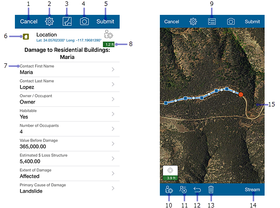
The diagram below shows the attribute list of a point feature on the left, and the map that appears when collecting a line feature on the right. As noted below, some of the tools that display in the map when collecting a line or polygon feature don't display when you are collecting point features. Both screens are shown here so that you can see all of the available collection tools.
The diagrams below show what you see when using Collector on an iPhone. What you see when working with an iPad is similar, however, there are a few key differences. One is that the Attributes list and Map display at the same time. Also, when working with an iPad, you won't see Current Accuracy in the Attributes list as you do on an iPhone.

The following items are highlighted on the previous image of the Collect screen:
- Cancel—Discards the feature if you are collecting a new feature, or discards your edits if you are editing an existing feature.
- Collect Settings—View and update the required accuracy and streaming interval used during collection.
- View Map—Shows the map if you are viewing the attributes list.
- Add Attachment—Adds attachments such as photos and videos to a feature if attachments are enabled in the map.
- Submit or Update—Saves the feature and the data you collected about it. Submit (shown here), appears when you are creating a new feature. Update (not shown) appears when you are editing an existing feature.
- Feature type—Indicates the type of feature you are collecting.
- Fields—Enter information about the feature in each of the fields shown.
- Current Accuracy—Like the Location Accuracy badge, indicates current horizontal accuracy as well as whether the current accuracy is below the threshold required to use the GPS to collect data. Unlike the Location Accuracy badge, selecting this does not display more details about your current GPS location.
- Collect Attributes—Shows the Attributes list.
- Use My Location—Updates the feature's location or adds a new vertex using the GPS.
- Delete Vertex—Deletes the currently active vertex of your polygon or line feature. It only displays when you are collecting or editing a polygon or line feature.
- Undo—Reverts the last change you made to the shape of a feature. For example, if you update the location of a feature or add a point to a shape you're drawing, selecting Undo discards these changes. However, if you edit a field in the Attributes list and select Undo, your field edits are unaffected and the last change made to the feature's shape is undone.
- Delete—Discards the line or polygon feature you are collecting or editing. This tool only displays when you are working with polygon or line features.
- Stream—Automatically collects a shape using your device's GPS, allowing you to walk or drive along a feature and capture its shape without manually placing points. When selected, it changes to Pause and you can't manually edit the shape. To make manual edits, pause streaming, make your updates, and restart streaming. You can only stream when collecting or editing a polygon or line.
- Map—Allows you to create and edit the feature's shape. For details on working with the shape of features, see Draw a shape.
Map Gallery
Use the Map Gallery to open or find a different map. You can also manage your login from the Map Gallery.
To go to the Map Gallery, select Maps when viewing a map, or start the app while there is no open map. The currently open map is highlighted in the Map Gallery. When first opening the app, the most recently used map will be at the top of the gallery. To expand the menu when viewing the Map Gallery, select the gallery title.
Note:
The available maps include maps your signed-in account can access. If you used the app's Try it option, the available maps are the sample maps.

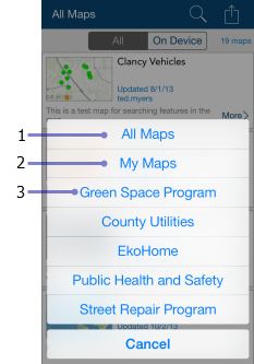
The following items are highlighted on the previous image of the Map Gallery:
- Gallery title—Expands the menu. Describes the group of maps you see. It is one of the following:
- All Maps (as shown in the image)—Shows all available maps, including those you authored and those available to groups of which you are a member.
- My Maps—Shows all the maps you authored. They are shown as a flat list, ignoring any folders that you have set up.
- A group name shows all the maps shared with that group.
- Gallery filter—Filters the gallery to show all maps or only those stored on the device.
- Search maps—Searches the displayed maps for the particular map you want to open. The available maps filter to only display maps whose title, summary, or tags match your search.
- Action—Provides access to:
- Sign Out—Sign out of the app.
- My Organization—View information about your organization.
- Settings—View and update the account settings.
- About—View the version of Collector and the license agreement.
- Manage—Manage maps downloaded to your device.
Note:
Manage only appears if you have maps downloaded to your device.
- Map count—The number of maps included in the gallery.
- Map card—An available map. Select the map thumbnail to open it.
- More—Provides access to reload the map if it is open, open a map or return to it if it's already open, and show the map's details.
- Download—Starts downloading your map. Download is only visible if the map can be taken offline. For details, see Go offline.
Menu
Use the menu to access collections of maps.
To expand the menu while viewing the Map Gallery, select the gallery title. If you are viewing a map, return to the Map Gallery by selecting Maps, and expand the menu.

Note:
If you are using the Try it option, the menu is slightly different, and you won't see My Maps.
- All—Select to set the gallery to show all maps you can access. This includes all maps you authored, as well as those available to groups of which you are a member.
- My Maps—Set the Map Gallery to show all the maps you authored.
- Group maps—Displays the names of all groups of which you are a member and which have data collection maps. Select the name of a group to set the Map Gallery to show all the maps that are shared with that group. The signed-in user in the screen capture is a member of multiple groups including Green Space Program and Public Health and Safety.